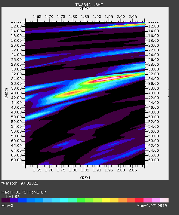
334A Lometa, TX, USA - Earthquake Result Viewer
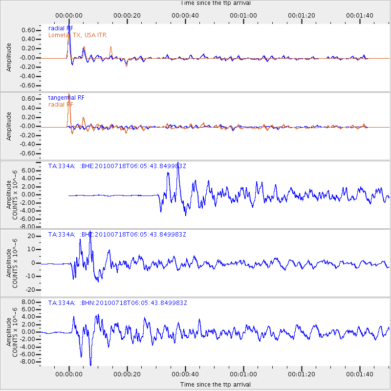
Earthquake location: Fox Islands, Aleutian Islands
Earthquake latitude/longitude: 52.9/-169.8
Earthquake time(UTC): 2010/07/18 (199) 05:56:44 GMT
Earthquake Depth: 14 km
Earthquake Magnitude: 6.3 MB, 6.7 MS, 6.6 MW, 6.6 MW
Earthquake Catalog/Contributor: WHDF/NEIC
Network: TA USArray Transportable Network (new EarthScope stations)
Station: 334A Lometa, TX, USA
Lat/Lon: 31.33 N/98.24 W
Elevation: 389 m
Distance: 54.9 deg
Az: 83.054 deg
Baz: 315.322 deg
Ray Param: 0.06515017
Estimated Moho Depth: 33.75 km
Estimated Crust Vp/Vs: 1.95
Assumed Crust Vp: 6.498 km/s
Estimated Crust Vs: 3.332 km/s
Estimated Crust Poisson's Ratio: 0.32
Radial Match: 97.82321 %
Radial Bump: 350
Transverse Match: 91.55606 %
Transverse Bump: 400
SOD ConfigId: 319893
Insert Time: 2011-01-05 06:04:14.652 +0000
GWidth: 2.5
Max Bumps: 400
Tol: 0.001

Signal To Noise

ChannelStoNSTALTA
TA:334A: :BHZ:20100718T06:05:43.849983Z82.162596.411662E-67.803627E-8
TA:334A: :BHN:20100718T06:05:43.849983Z24.1070882.3693801E-69.828562E-8
TA:334A: :BHE:20100718T06:05:43.849983Z38.7085952.3617004E-66.10123E-8
Arrivals
Ps5.2 SECOND
PpPs15 SECOND
PsPs/PpSs20 SECOND