You are here: Home > Network List > TA - USArray Transportable Network (new EarthScope stations) Stations List
> Station 734A La Parita Creek, Jourdanton, TX, USA > Earthquake Result Viewer
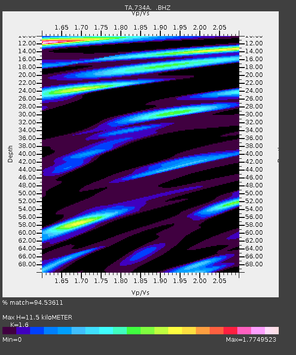
734A La Parita Creek, Jourdanton, TX, USA - Earthquake Result Viewer
| Earthquake location: |
Fox Islands, Aleutian Islands |
| Earthquake latitude/longitude: |
52.9/-169.8 |
| Earthquake time(UTC): |
2010/07/18 (199) 05:56:44 GMT |
| Earthquake Depth: |
14 km |
| Earthquake Magnitude: |
6.3 MB, 6.7 MS, 6.6 MW, 6.6 MW |
| Earthquake Catalog/Contributor: |
WHDF/NEIC |
|
| Network: |
TA USArray Transportable Network (new EarthScope stations) |
| Station: |
734A La Parita Creek, Jourdanton, TX, USA |
| Lat/Lon: |
28.85 N/98.56 W |
| Elevation: |
121 m |
|
| Distance: |
56.5 deg |
| Az: |
85.382 deg |
| Baz: |
316.475 deg |
| Ray Param: |
0.06411015 |
| Estimated Moho Depth: |
11.5 km |
| Estimated Crust Vp/Vs: |
1.60 |
| Assumed Crust Vp: |
6.347 km/s |
| Estimated Crust Vs: |
3.967 km/s |
| Estimated Crust Poisson's Ratio: |
0.18 |
|
| Radial Match: |
94.53611 % |
| Radial Bump: |
400 |
| Transverse Match: |
88.73495 % |
| Transverse Bump: |
400 |
| SOD ConfigId: |
319893 |
| Insert Time: |
2011-01-05 06:04:49.299 +0000 |
| GWidth: |
2.5 |
| Max Bumps: |
400 |
| Tol: |
0.001 |
|

Signal To Noise
| Channel | StoN | STA | LTA |
| TA:734A: :BHZ:20100718T06:05:55.224983Z | 73.26272 | 8.0373575E-6 | 1.0970597E-7 |
| TA:734A: :BHN:20100718T06:05:55.224983Z | 16.390804 | 1.7991129E-6 | 1.09763555E-7 |
| TA:734A: :BHE:20100718T06:05:55.224983Z | 6.5708985 | 1.2939778E-6 | 1.9692554E-7 |
| Arrivals |
| Ps | 1.1 SECOND |
| PpPs | 4.5 SECOND |
| PsPs/PpSs | 5.6 SECOND |


