You are here: Home > Network List > TA - USArray Transportable Network (new EarthScope stations) Stations List
> Station 436A Wall Ranch, Gause, TX, USA > Earthquake Result Viewer
436A Wall Ranch, Gause, TX, USA - Earthquake Result Viewer
| Earthquake location: |
Fox Islands, Aleutian Islands |
| Earthquake latitude/longitude: |
52.9/-169.8 |
| Earthquake time(UTC): |
2010/07/18 (199) 05:56:44 GMT |
| Earthquake Depth: |
14 km |
| Earthquake Magnitude: |
6.3 MB, 6.7 MS, 6.6 MW, 6.6 MW |
| Earthquake Catalog/Contributor: |
WHDF/NEIC |
|
| Network: |
TA USArray Transportable Network (new EarthScope stations) |
| Station: |
436A Wall Ranch, Gause, TX, USA |
| Lat/Lon: |
30.77 N/96.80 W |
| Elevation: |
109 m |
|
| Distance: |
56.2 deg |
| Az: |
82.46 deg |
| Baz: |
315.725 deg |
| Ray Param: |
0.064317934 |
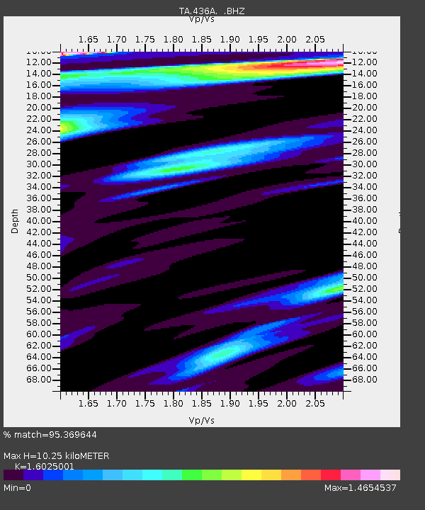
| Estimated Moho Depth: |
10.25 km |
| Estimated Crust Vp/Vs: |
1.60 |
| Assumed Crust Vp: |
6.347 km/s |
| Estimated Crust Vs: |
3.961 km/s |
| Estimated Crust Poisson's Ratio: |
0.18 |
|
| Radial Match: |
95.369644 % |
| Radial Bump: |
358 |
| Transverse Match: |
87.976234 % |
| Transverse Bump: |
400 |
| SOD ConfigId: |
319893 |
| Insert Time: |
2011-01-05 06:06:38.520 +0000 |
| GWidth: |
2.5 |
| Max Bumps: |
400 |
| Tol: |
0.001 |
|
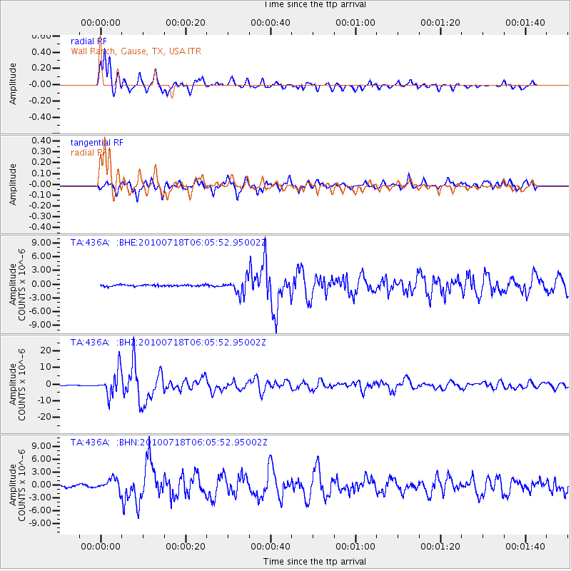
Signal To Noise
| Channel | StoN | STA | LTA |
| TA:436A: :BHZ:20100718T06:05:52.95002Z | 44.042904 | 7.5656108E-6 | 1.717782E-7 |
| TA:436A: :BHN:20100718T06:05:52.95002Z | 2.5124247 | 1.4364705E-6 | 5.717467E-7 |
| TA:436A: :BHE:20100718T06:05:52.95002Z | 10.730281 | 1.6427529E-6 | 1.5309504E-7 |
| Arrivals |
| Ps | 1.0 SECOND |
| PpPs | 4.0 SECOND |
| PsPs/PpSs | 5.0 SECOND |


