You are here: Home > Network List > UW - Pacific Northwest Regional Seismic Network Stations List
> Station UMAT Pilot Rock, OR, USA > Earthquake Result Viewer
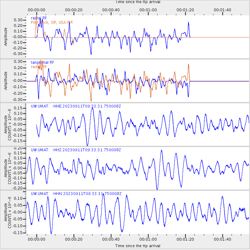
UMAT Pilot Rock, OR, USA - Earthquake Result Viewer
*The percent match for this event was below the threshold and hence no stack was calculated.
| Earthquake location: |
Central Mid-Atlantic Ridge |
| Earthquake latitude/longitude: |
0.7/-26.1 |
| Earthquake time(UTC): |
2023/09/11 (254) 09:20:56 GMT |
| Earthquake Depth: |
10 km |
| Earthquake Magnitude: |
5.9 Mww |
| Earthquake Catalog/Contributor: |
NEIC PDE/us |
|
| Network: |
UW Pacific Northwest Regional Seismic Network |
| Station: |
UMAT Pilot Rock, OR, USA |
| Lat/Lon: |
45.29 N/118.96 W |
| Elevation: |
1318 m |
|
| Distance: |
91.5 deg |
| Az: |
315.15 deg |
| Baz: |
87.442 deg |
| Ray Param: |
$rayparam |
*The percent match for this event was below the threshold and hence was not used in the summary stack. |
|
| Radial Match: |
60.64593 % |
| Radial Bump: |
361 |
| Transverse Match: |
49.459923 % |
| Transverse Bump: |
303 |
| SOD ConfigId: |
31937991 |
| Insert Time: |
2023-09-25 09:47:21.417 +0000 |
| GWidth: |
2.5 |
| Max Bumps: |
400 |
| Tol: |
0.001 |
|
Signal To Noise
| Channel | StoN | STA | LTA |
| UW:UMAT: :HHZ:20230911T09:33:31.750008Z | 0.80363 | 5.374276E-8 | 6.6875E-8 |
| UW:UMAT: :HHN:20230911T09:33:31.750008Z | 0.9897337 | 4.7228117E-8 | 4.7718004E-8 |
| UW:UMAT: :HHE:20230911T09:33:31.750008Z | 2.2741444 | 1.0621083E-7 | 4.6703644E-8 |
| Arrivals |
| Ps | |
| PpPs | |
| PsPs/PpSs | |


