You are here: Home > Network List > AK - Alaska Regional Network Stations List
> Station F20K Avaraart Lake, AK, USA > Earthquake Result Viewer
F20K Avaraart Lake, AK, USA - Earthquake Result Viewer
| Earthquake location: |
Halmahera, Indonesia |
| Earthquake latitude/longitude: |
1.1/127.5 |
| Earthquake time(UTC): |
2023/09/11 (254) 12:51:34 GMT |
| Earthquake Depth: |
163 km |
| Earthquake Magnitude: |
6.0 mww |
| Earthquake Catalog/Contributor: |
NEIC PDE/us |
|
| Network: |
AK Alaska Regional Network |
| Station: |
F20K Avaraart Lake, AK, USA |
| Lat/Lon: |
67.05 N/155.73 W |
| Elevation: |
136 m |
|
| Distance: |
83.8 deg |
| Az: |
22.584 deg |
| Baz: |
258.251 deg |
| Ray Param: |
0.04553814 |
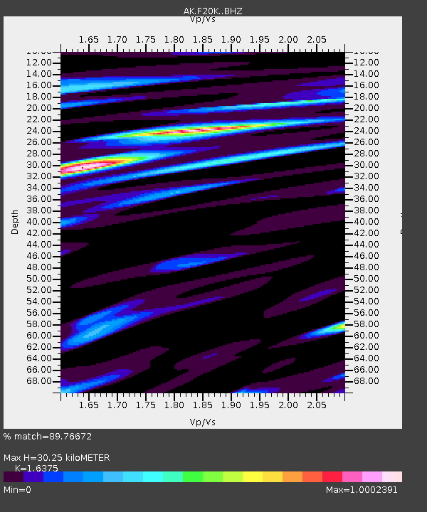
| Estimated Moho Depth: |
30.25 km |
| Estimated Crust Vp/Vs: |
1.64 |
| Assumed Crust Vp: |
6.522 km/s |
| Estimated Crust Vs: |
3.983 km/s |
| Estimated Crust Poisson's Ratio: |
0.20 |
|
| Radial Match: |
89.76672 % |
| Radial Bump: |
312 |
| Transverse Match: |
86.522644 % |
| Transverse Bump: |
400 |
| SOD ConfigId: |
31937991 |
| Insert Time: |
2023-09-25 12:54:11.712 +0000 |
| GWidth: |
2.5 |
| Max Bumps: |
400 |
| Tol: |
0.001 |
|

Signal To Noise
| Channel | StoN | STA | LTA |
| AK:F20K: :BHZ:20230911T13:03:14.399979Z | 8.586167 | 5.311214E-7 | 6.18578E-8 |
| AK:F20K: :BHN:20230911T13:03:14.399979Z | 1.1714838 | 8.342075E-8 | 7.120948E-8 |
| AK:F20K: :BHE:20230911T13:03:14.399979Z | 3.5814638 | 2.033825E-7 | 5.6787535E-8 |
| Arrivals |
| Ps | 3.0 SECOND |
| PpPs | 12 SECOND |
| PsPs/PpSs | 15 SECOND |


