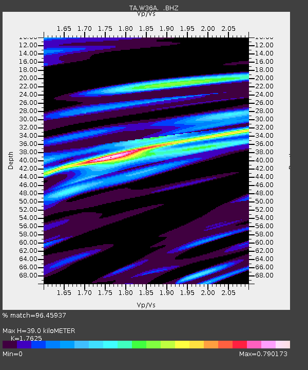
W36A Wetumka, OK, USA - Earthquake Result Viewer
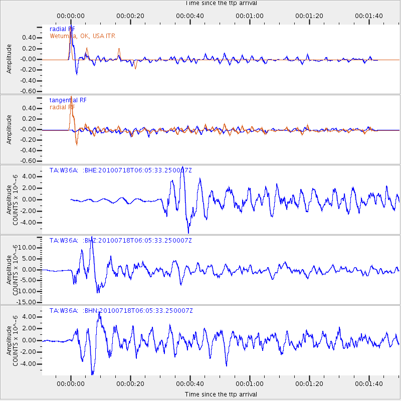
Earthquake location: Fox Islands, Aleutian Islands
Earthquake latitude/longitude: 52.9/-169.8
Earthquake time(UTC): 2010/07/18 (199) 05:56:44 GMT
Earthquake Depth: 14 km
Earthquake Magnitude: 6.3 MB, 6.7 MS, 6.6 MW, 6.6 MW
Earthquake Catalog/Contributor: WHDF/NEIC
Network: TA USArray Transportable Network (new EarthScope stations)
Station: W36A Wetumka, OK, USA
Lat/Lon: 35.14 N/96.23 W
Elevation: 251 m
Distance: 53.4 deg
Az: 78.255 deg
Baz: 313.608 deg
Ray Param: 0.06609557
Estimated Moho Depth: 39.0 km
Estimated Crust Vp/Vs: 1.76
Assumed Crust Vp: 6.426 km/s
Estimated Crust Vs: 3.646 km/s
Estimated Crust Poisson's Ratio: 0.26
Radial Match: 96.45937 %
Radial Bump: 324
Transverse Match: 84.12032 %
Transverse Bump: 400
SOD ConfigId: 319893
Insert Time: 2011-01-05 06:09:23.992 +0000
GWidth: 2.5
Max Bumps: 400
Tol: 0.001

Signal To Noise

ChannelStoNSTALTA
TA:W36A: :BHZ:20100718T06:05:33.250007Z14.506824.0426526E-62.7867256E-7
TA:W36A: :BHN:20100718T06:05:33.250007Z7.3142551.558099E-62.1302225E-7
TA:W36A: :BHE:20100718T06:05:33.250007Z7.23203951.7634496E-62.438385E-7
Arrivals
Ps4.9 SECOND
PpPs16 SECOND
PsPs/PpSs21 SECOND