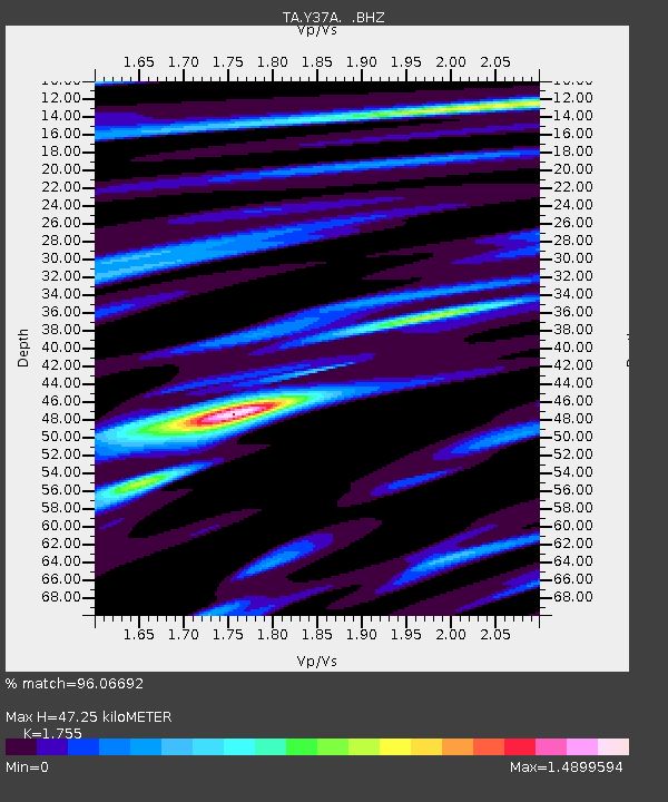
Y37A Hugo, OK, USA - Earthquake Result Viewer
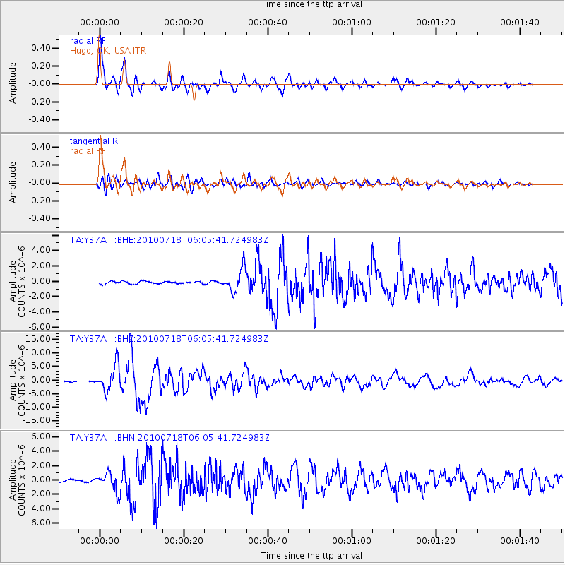
Earthquake location: Fox Islands, Aleutian Islands
Earthquake latitude/longitude: 52.9/-169.8
Earthquake time(UTC): 2010/07/18 (199) 05:56:44 GMT
Earthquake Depth: 14 km
Earthquake Magnitude: 6.3 MB, 6.7 MS, 6.6 MW, 6.6 MW
Earthquake Catalog/Contributor: WHDF/NEIC
Network: TA USArray Transportable Network (new EarthScope stations)
Station: Y37A Hugo, OK, USA
Lat/Lon: 33.98 N/95.62 W
Elevation: 165 m
Distance: 54.6 deg
Az: 78.856 deg
Baz: 314.303 deg
Ray Param: 0.06534207
Estimated Moho Depth: 47.25 km
Estimated Crust Vp/Vs: 1.75
Assumed Crust Vp: 6.245 km/s
Estimated Crust Vs: 3.558 km/s
Estimated Crust Poisson's Ratio: 0.26
Radial Match: 96.06692 %
Radial Bump: 400
Transverse Match: 87.77638 %
Transverse Bump: 400
SOD ConfigId: 319893
Insert Time: 2011-01-05 06:10:37.699 +0000
GWidth: 2.5
Max Bumps: 400
Tol: 0.001

Signal To Noise

ChannelStoNSTALTA
TA:Y37A: :BHZ:20100718T06:05:41.724983Z27.4561964.7707035E-61.7375689E-7
TA:Y37A: :BHN:20100718T06:05:41.724983Z9.6016691.3576978E-61.4140225E-7
TA:Y37A: :BHE:20100718T06:05:41.724983Z9.7625221.5047668E-61.541371E-7
Arrivals
Ps6.0 SECOND
PpPs20 SECOND
PsPs/PpSs26 SECOND