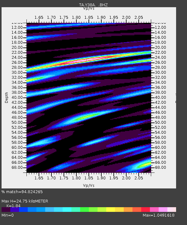
Y38A Idabel, OK, USA - Earthquake Result Viewer
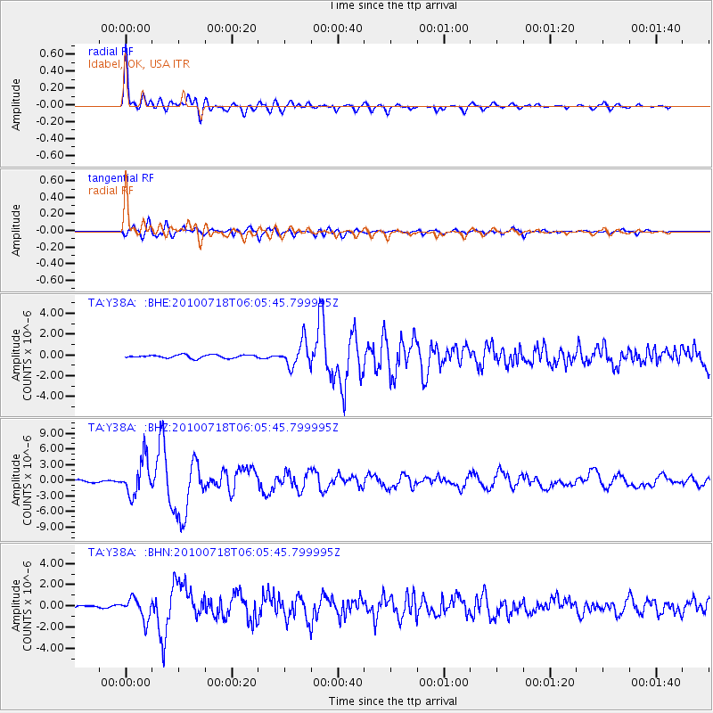
Earthquake location: Fox Islands, Aleutian Islands
Earthquake latitude/longitude: 52.9/-169.8
Earthquake time(UTC): 2010/07/18 (199) 05:56:44 GMT
Earthquake Depth: 14 km
Earthquake Magnitude: 6.3 MB, 6.7 MS, 6.6 MW, 6.6 MW
Earthquake Catalog/Contributor: WHDF/NEIC
Network: TA USArray Transportable Network (new EarthScope stations)
Station: Y38A Idabel, OK, USA
Lat/Lon: 33.93 N/94.73 W
Elevation: 118 m
Distance: 55.2 deg
Az: 78.268 deg
Baz: 314.46 deg
Ray Param: 0.0649692
Estimated Moho Depth: 24.75 km
Estimated Crust Vp/Vs: 1.84
Assumed Crust Vp: 6.245 km/s
Estimated Crust Vs: 3.394 km/s
Estimated Crust Poisson's Ratio: 0.29
Radial Match: 94.824265 %
Radial Bump: 400
Transverse Match: 84.51363 %
Transverse Bump: 400
SOD ConfigId: 319893
Insert Time: 2011-01-05 06:10:42.560 +0000
GWidth: 2.5
Max Bumps: 400
Tol: 0.001

Signal To Noise

ChannelStoNSTALTA
TA:Y38A: :BHZ:20100718T06:05:45.799995Z11.6575133.4356037E-62.9471155E-7
TA:Y38A: :BHN:20100718T06:05:45.799995Z4.78223851.0103382E-62.1126888E-7
TA:Y38A: :BHE:20100718T06:05:45.799995Z7.80159241.2269705E-61.5727181E-7
Arrivals
Ps3.5 SECOND
PpPs11 SECOND
PsPs/PpSs14 SECOND