You are here: Home > Network List > GO - National Seismic Network of Georgia Stations List
> Station MINA Georgia, Mina > Earthquake Result Viewer
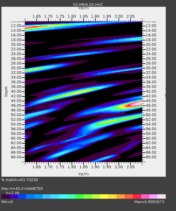
MINA Georgia, Mina - Earthquake Result Viewer
| Earthquake location: |
Halmahera, Indonesia |
| Earthquake latitude/longitude: |
1.1/127.5 |
| Earthquake time(UTC): |
2023/09/11 (254) 12:51:34 GMT |
| Earthquake Depth: |
163 km |
| Earthquake Magnitude: |
6.0 mww |
| Earthquake Catalog/Contributor: |
NEIC PDE/us |
|
| Network: |
GO National Seismic Network of Georgia |
| Station: |
MINA Georgia, Mina |
| Lat/Lon: |
41.60 N/43.02 E |
| Elevation: |
1568 m |
|
| Distance: |
85.1 deg |
| Az: |
311.472 deg |
| Baz: |
92.83 deg |
| Ray Param: |
0.044627823 |
| Estimated Moho Depth: |
45.0 km |
| Estimated Crust Vp/Vs: |
2.09 |
| Assumed Crust Vp: |
6.419 km/s |
| Estimated Crust Vs: |
3.071 km/s |
| Estimated Crust Poisson's Ratio: |
0.35 |
|
| Radial Match: |
83.70038 % |
| Radial Bump: |
400 |
| Transverse Match: |
79.326416 % |
| Transverse Bump: |
400 |
| SOD ConfigId: |
31937991 |
| Insert Time: |
2023-09-25 13:00:47.438 +0000 |
| GWidth: |
2.5 |
| Max Bumps: |
400 |
| Tol: |
0.001 |
|

Signal To Noise
| Channel | StoN | STA | LTA |
| GO:MINA:00:HHZ:20230911T13:03:20.789994Z | 26.903341 | 1.3375553E-6 | 4.971707E-8 |
| GO:MINA:00:HHN:20230911T13:03:20.789994Z | 6.9126863 | 3.3881852E-7 | 4.901402E-8 |
| GO:MINA:00:HHE:20230911T13:03:20.789994Z | 3.904961 | 2.3688463E-7 | 6.066248E-8 |
| Arrivals |
| Ps | 7.8 SECOND |
| PpPs | 21 SECOND |
| PsPs/PpSs | 29 SECOND |


