You are here: Home > Network List > TA - USArray Transportable Network (new EarthScope stations) Stations List
> Station P36A Good Intent, Atchison, KS, USA > Earthquake Result Viewer
P36A Good Intent, Atchison, KS, USA - Earthquake Result Viewer

| Earthquake location: |
Fox Islands, Aleutian Islands |
| Earthquake latitude/longitude: |
52.9/-169.8 |
| Earthquake time(UTC): |
2010/07/18 (199) 05:56:44 GMT |
| Earthquake Depth: |
14 km |
| Earthquake Magnitude: |
6.3 MB, 6.7 MS, 6.6 MW, 6.6 MW |
| Earthquake Catalog/Contributor: |
WHDF/NEIC |
|
| Network: |
TA USArray Transportable Network (new EarthScope stations) |
| Station: |
P36A Good Intent, Atchison, KS, USA |
| Lat/Lon: |
39.62 N/95.21 W |
| Elevation: |
313 m |
|
| Distance: |
51.0 deg |
| Az: |
73.383 deg |
| Baz: |
311.239 deg |
| Ray Param: |
0.06767155 |
| Estimated Moho Depth: |
41.5 km |
| Estimated Crust Vp/Vs: |
1.75 |
| Assumed Crust Vp: |
6.498 km/s |
| Estimated Crust Vs: |
3.708 km/s |
| Estimated Crust Poisson's Ratio: |
0.26 |
|
| Radial Match: |
94.39251 % |
| Radial Bump: |
400 |
| Transverse Match: |
79.0267 % |
| Transverse Bump: |
400 |
| SOD ConfigId: |
319893 |
| Insert Time: |
2011-01-05 06:12:45.580 +0000 |
| GWidth: |
2.5 |
| Max Bumps: |
400 |
| Tol: |
0.001 |
|
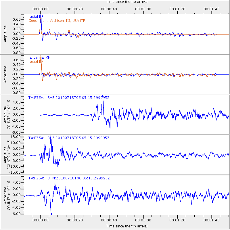
Signal To Noise
| Channel | StoN | STA | LTA |
| TA:P36A: :BHZ:20100718T06:05:15.299995Z | 19.258045 | 3.6779618E-6 | 1.9098313E-7 |
| TA:P36A: :BHN:20100718T06:05:15.299995Z | 9.624548 | 1.3981406E-6 | 1.4526819E-7 |
| TA:P36A: :BHE:20100718T06:05:15.299995Z | 9.630878 | 1.3868622E-6 | 1.4400162E-7 |
| Arrivals |
| Ps | 5.1 SECOND |
| PpPs | 17 SECOND |
| PsPs/PpSs | 22 SECOND |


