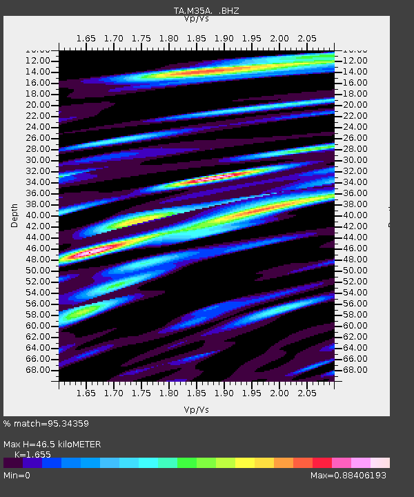
M35A Neola, IA, USA - Earthquake Result Viewer
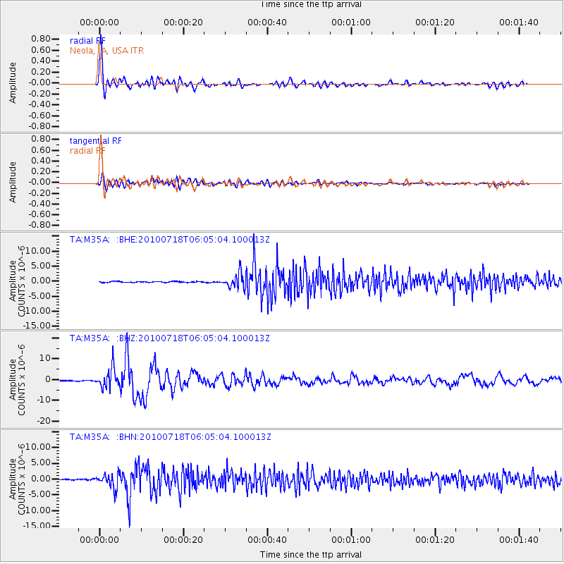
Earthquake location: Fox Islands, Aleutian Islands
Earthquake latitude/longitude: 52.9/-169.8
Earthquake time(UTC): 2010/07/18 (199) 05:56:44 GMT
Earthquake Depth: 14 km
Earthquake Magnitude: 6.3 MB, 6.7 MS, 6.6 MW, 6.6 MW
Earthquake Catalog/Contributor: WHDF/NEIC
Network: TA USArray Transportable Network (new EarthScope stations)
Station: M35A Neola, IA, USA
Lat/Lon: 41.47 N/95.69 W
Elevation: 363 m
Distance: 49.5 deg
Az: 71.878 deg
Baz: 309.96 deg
Ray Param: 0.06863339
Estimated Moho Depth: 46.5 km
Estimated Crust Vp/Vs: 1.65
Assumed Crust Vp: 6.498 km/s
Estimated Crust Vs: 3.926 km/s
Estimated Crust Poisson's Ratio: 0.21
Radial Match: 95.34359 %
Radial Bump: 400
Transverse Match: 82.30006 %
Transverse Bump: 400
SOD ConfigId: 319893
Insert Time: 2011-01-05 06:13:35.752 +0000
GWidth: 2.5
Max Bumps: 400
Tol: 0.001

Signal To Noise

ChannelStoNSTALTA
TA:M35A: :BHZ:20100718T06:05:04.100013Z35.8920364.6295854E-61.2898643E-7
TA:M35A: :BHN:20100718T06:05:04.100013Z13.8187322.242908E-61.6230923E-7
TA:M35A: :BHE:20100718T06:05:04.100013Z15.9951082.4757965E-61.547846E-7
Arrivals
Ps5.0 SECOND
PpPs18 SECOND
PsPs/PpSs23 SECOND