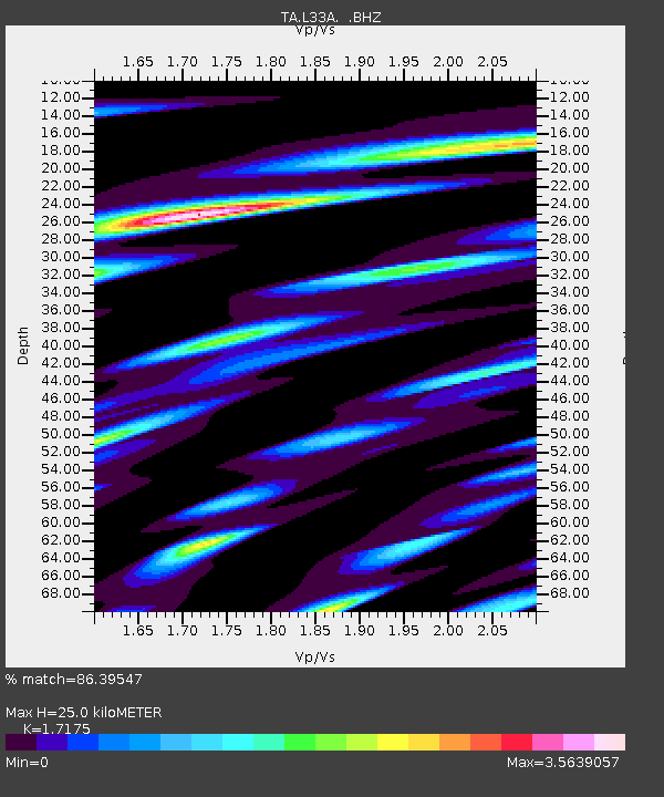
L33A Hoskins, NE, USA - Earthquake Result Viewer
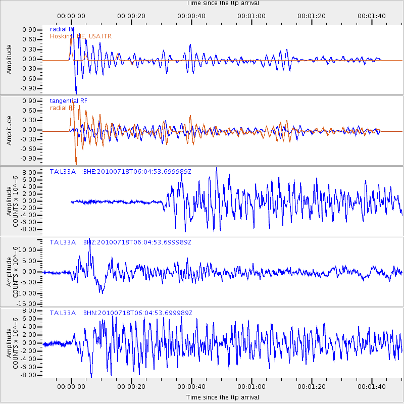
Earthquake location: Fox Islands, Aleutian Islands
Earthquake latitude/longitude: 52.9/-169.8
Earthquake time(UTC): 2010/07/18 (199) 05:56:44 GMT
Earthquake Depth: 14 km
Earthquake Magnitude: 6.3 MB, 6.7 MS, 6.6 MW, 6.6 MW
Earthquake Catalog/Contributor: WHDF/NEIC
Network: TA USArray Transportable Network (new EarthScope stations)
Station: L33A Hoskins, NE, USA
Lat/Lon: 42.17 N/97.27 W
Elevation: 556 m
Distance: 48.2 deg
Az: 72.159 deg
Baz: 309.097 deg
Ray Param: 0.069518484
Estimated Moho Depth: 25.0 km
Estimated Crust Vp/Vs: 1.72
Assumed Crust Vp: 6.498 km/s
Estimated Crust Vs: 3.783 km/s
Estimated Crust Poisson's Ratio: 0.24
Radial Match: 86.39547 %
Radial Bump: 400
Transverse Match: 76.639656 %
Transverse Bump: 400
SOD ConfigId: 319893
Insert Time: 2011-01-05 06:14:00.947 +0000
GWidth: 2.5
Max Bumps: 400
Tol: 0.001

Signal To Noise

ChannelStoNSTALTA
TA:L33A: :BHZ:20100718T06:04:53.699989Z11.5125312.8412655E-62.467976E-7
TA:L33A: :BHN:20100718T06:04:53.699989Z6.1274561.7767072E-62.899584E-7
TA:L33A: :BHE:20100718T06:04:53.699989Z11.6400412.3458383E-62.0153179E-7
Arrivals
Ps2.9 SECOND
PpPs9.8 SECOND
PsPs/PpSs13 SECOND