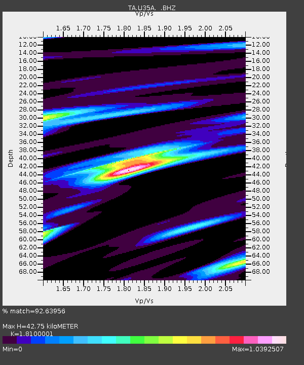
U35A Pawnee, OK, USA - Earthquake Result Viewer

Earthquake location: Fox Islands, Aleutian Islands
Earthquake latitude/longitude: 52.9/-169.8
Earthquake time(UTC): 2010/07/18 (199) 05:56:44 GMT
Earthquake Depth: 14 km
Earthquake Magnitude: 6.3 MB, 6.7 MS, 6.6 MW, 6.6 MW
Earthquake Catalog/Contributor: WHDF/NEIC
Network: TA USArray Transportable Network (new EarthScope stations)
Station: U35A Pawnee, OK, USA
Lat/Lon: 36.37 N/96.73 W
Elevation: 303 m
Distance: 52.3 deg
Az: 77.485 deg
Baz: 312.849 deg
Ray Param: 0.06684546
Estimated Moho Depth: 42.75 km
Estimated Crust Vp/Vs: 1.81
Assumed Crust Vp: 6.483 km/s
Estimated Crust Vs: 3.582 km/s
Estimated Crust Poisson's Ratio: 0.28
Radial Match: 92.63956 %
Radial Bump: 400
Transverse Match: 76.31941 %
Transverse Bump: 400
SOD ConfigId: 319893
Insert Time: 2011-01-05 06:14:13.071 +0000
GWidth: 2.5
Max Bumps: 400
Tol: 0.001

Signal To Noise

ChannelStoNSTALTA
TA:U35A: :BHZ:20100718T06:05:24.849983Z11.9297032.9033645E-62.4337274E-7
TA:U35A: :BHN:20100718T06:05:24.849983Z3.6982611.0701317E-62.893608E-7
TA:U35A: :BHE:20100718T06:05:24.849983Z8.6493991.2891552E-61.4904563E-7
Arrivals
Ps5.6 SECOND
PpPs18 SECOND
PsPs/PpSs23 SECOND