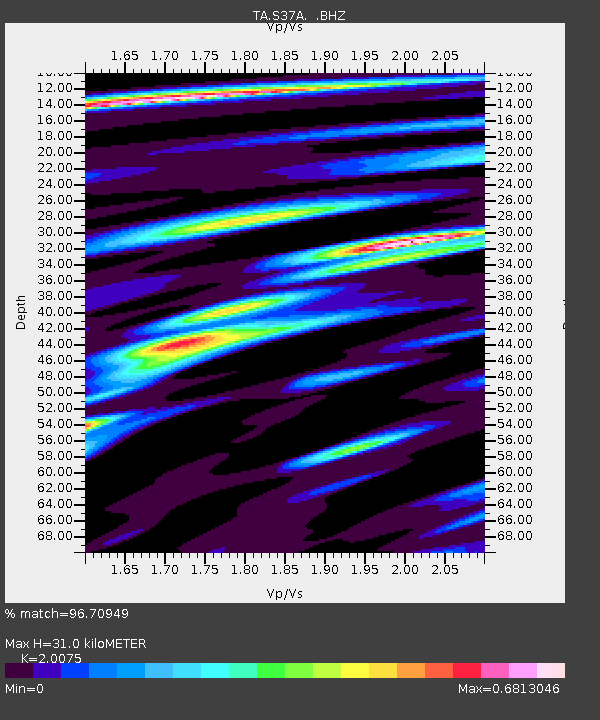
S37A Fort Scott, KS, USA - Earthquake Result Viewer

Earthquake location: Fox Islands, Aleutian Islands
Earthquake latitude/longitude: 52.9/-169.8
Earthquake time(UTC): 2010/07/18 (199) 05:56:44 GMT
Earthquake Depth: 14 km
Earthquake Magnitude: 6.3 MB, 6.7 MS, 6.6 MW, 6.6 MW
Earthquake Catalog/Contributor: WHDF/NEIC
Network: TA USArray Transportable Network (new EarthScope stations)
Station: S37A Fort Scott, KS, USA
Lat/Lon: 37.76 N/94.83 W
Elevation: 260 m
Distance: 52.5 deg
Az: 74.895 deg
Baz: 312.411 deg
Ray Param: 0.06672919
Estimated Moho Depth: 31.0 km
Estimated Crust Vp/Vs: 2.01
Assumed Crust Vp: 6.53 km/s
Estimated Crust Vs: 3.253 km/s
Estimated Crust Poisson's Ratio: 0.33
Radial Match: 96.70949 %
Radial Bump: 390
Transverse Match: 73.151855 %
Transverse Bump: 400
SOD ConfigId: 319893
Insert Time: 2011-01-05 06:14:24.954 +0000
GWidth: 2.5
Max Bumps: 400
Tol: 0.001

Signal To Noise

ChannelStoNSTALTA
TA:S37A: :BHZ:20100718T06:05:26.174995Z17.5893763.8709572E-62.200736E-7
TA:S37A: :BHN:20100718T06:05:26.174995Z9.4872741.4803388E-61.5603416E-7
TA:S37A: :BHE:20100718T06:05:26.174995Z11.1358491.7122283E-61.5375821E-7
Arrivals
Ps5.0 SECOND
PpPs14 SECOND
PsPs/PpSs19 SECOND