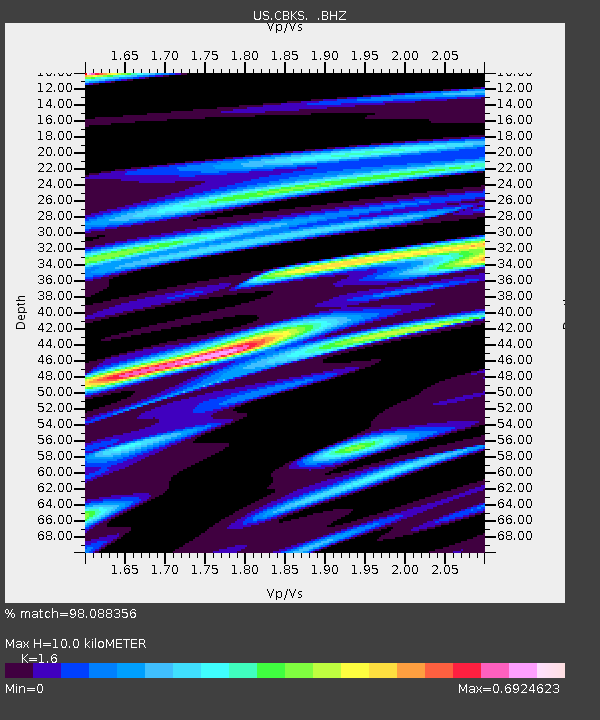
CBKS Cedar Bluff, Kansas, USA - Earthquake Result Viewer

Earthquake location: Fox Islands, Aleutian Islands
Earthquake latitude/longitude: 52.9/-169.8
Earthquake time(UTC): 2010/07/18 (199) 05:56:44 GMT
Earthquake Depth: 14 km
Earthquake Magnitude: 6.3 MB, 6.7 MS, 6.6 MW, 6.6 MW
Earthquake Catalog/Contributor: WHDF/NEIC
Network: US United States National Seismic Network
Station: CBKS Cedar Bluff, Kansas, USA
Lat/Lon: 38.81 N/99.74 W
Elevation: 677 m
Distance: 48.9 deg
Az: 77.195 deg
Baz: 310.839 deg
Ray Param: 0.06905393
Estimated Moho Depth: 10.0 km
Estimated Crust Vp/Vs: 1.60
Assumed Crust Vp: 6.483 km/s
Estimated Crust Vs: 4.052 km/s
Estimated Crust Poisson's Ratio: 0.18
Radial Match: 98.088356 %
Radial Bump: 283
Transverse Match: 82.18636 %
Transverse Bump: 400
SOD ConfigId: 319893
Insert Time: 2011-01-05 06:15:38.591 +0000
GWidth: 2.5
Max Bumps: 400
Tol: 0.001

Signal To Noise

ChannelStoNSTALTA
US:CBKS: :BHZ:20100718T06:04:59.174995Z34.2037354.71482E-61.3784519E-7
US:CBKS: :BHN:20100718T06:04:59.174995Z20.550262.0128937E-69.794979E-8
US:CBKS: :BHE:20100718T06:04:59.174995Z15.6259641.8244568E-61.1675803E-7
Arrivals
Ps1.0 SECOND
PpPs3.7 SECOND
PsPs/PpSs4.7 SECOND