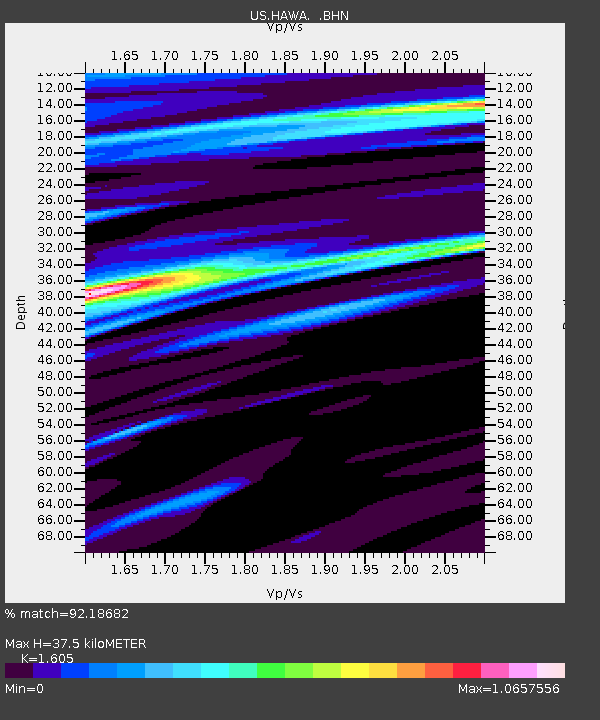
HAWA Hanford, Washington, USA - Earthquake Result Viewer

Earthquake location: Fox Islands, Aleutian Islands
Earthquake latitude/longitude: 52.9/-169.8
Earthquake time(UTC): 2010/07/18 (199) 05:56:44 GMT
Earthquake Depth: 14 km
Earthquake Magnitude: 6.3 MB, 6.7 MS, 6.6 MW, 6.6 MW
Earthquake Catalog/Contributor: WHDF/NEIC
Network: US United States National Seismic Network
Station: HAWA Hanford, Washington, USA
Lat/Lon: 46.39 N/119.53 W
Elevation: 364 m
Distance: 32.7 deg
Az: 80.835 deg
Baz: 300.17 deg
Ray Param: 0.07855276
Estimated Moho Depth: 37.5 km
Estimated Crust Vp/Vs: 1.61
Assumed Crust Vp: 6.419 km/s
Estimated Crust Vs: 4.0 km/s
Estimated Crust Poisson's Ratio: 0.18
Radial Match: 92.18682 %
Radial Bump: 312
Transverse Match: 77.017784 %
Transverse Bump: 400
SOD ConfigId: 319893
Insert Time: 2011-01-05 06:16:33.490 +0000
GWidth: 2.5
Max Bumps: 400
Tol: 0.001

Signal To Noise

ChannelStoNSTALTA
US:HAWA: :BHZ:20100718T06:02:45.650001Z28.3608973.54991E-61.2516917E-7
US:HAWA: :BHN:20100718T06:02:45.650001Z10.9857461.0463431E-69.524552E-8
US:HAWA: :BHE:20100718T06:02:45.650001Z16.6669861.1507864E-66.904586E-8
Arrivals
Ps3.9 SECOND
PpPs14 SECOND
PsPs/PpSs18 SECOND