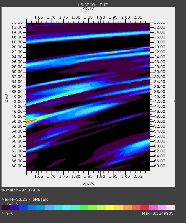
SDCO Great Sand Dunes National Park, Colorado, USA - Earthquake Result Viewer

Earthquake location: Fox Islands, Aleutian Islands
Earthquake latitude/longitude: 52.9/-169.8
Earthquake time(UTC): 2010/07/18 (199) 05:56:44 GMT
Earthquake Depth: 14 km
Earthquake Magnitude: 6.3 MB, 6.7 MS, 6.6 MW, 6.6 MW
Earthquake Catalog/Contributor: WHDF/NEIC
Network: US United States National Seismic Network
Station: SDCO Great Sand Dunes National Park, Colorado, USA
Lat/Lon: 37.75 N/105.50 W
Elevation: 2569 m
Distance: 46.1 deg
Az: 82.308 deg
Baz: 310.736 deg
Ray Param: 0.07081692
Estimated Moho Depth: 50.25 km
Estimated Crust Vp/Vs: 1.60
Assumed Crust Vp: 6.316 km/s
Estimated Crust Vs: 3.947 km/s
Estimated Crust Poisson's Ratio: 0.18
Radial Match: 97.07934 %
Radial Bump: 223
Transverse Match: 94.03862 %
Transverse Bump: 322
SOD ConfigId: 319893
Insert Time: 2011-01-05 06:17:14.439 +0000
GWidth: 2.5
Max Bumps: 400
Tol: 0.001

Signal To Noise

ChannelStoNSTALTA
US:SDCO: :BHZ:20100718T06:04:37.900001Z19.480133.0509027E-61.5661614E-7
US:SDCO: :BHN:20100718T06:04:37.900001Z5.83199364.282596E-77.34328E-8
US:SDCO: :BHE:20100718T06:04:37.900001Z13.1900861.4594066E-61.106442E-7
Arrivals
Ps5.1 SECOND
PpPs19 SECOND
PsPs/PpSs24 SECOND