You are here: Home > Network List > AV - Alaska Volcano Observatory Stations List
> Station MAPS Pakushin Southeast, Makushin Volcano, Alaska > Earthquake Result Viewer
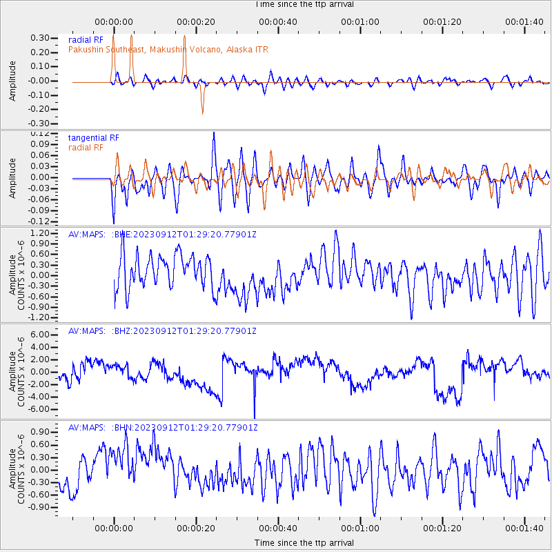
MAPS Pakushin Southeast, Makushin Volcano, Alaska - Earthquake Result Viewer
*The percent match for this event was below the threshold and hence no stack was calculated.
| Earthquake location: |
Solomon Islands |
| Earthquake latitude/longitude: |
-10.2/161.4 |
| Earthquake time(UTC): |
2023/09/12 (255) 01:18:54 GMT |
| Earthquake Depth: |
90 km |
| Earthquake Magnitude: |
5.5 Mww |
| Earthquake Catalog/Contributor: |
NEIC PDE/us |
|
| Network: |
AV Alaska Volcano Observatory |
| Station: |
MAPS Pakushin Southeast, Makushin Volcano, Alaska |
| Lat/Lon: |
53.81 N/166.94 W |
| Elevation: |
333 m |
|
| Distance: |
69.2 deg |
| Az: |
19.463 deg |
| Baz: |
213.579 deg |
| Ray Param: |
$rayparam |
*The percent match for this event was below the threshold and hence was not used in the summary stack. |
|
| Radial Match: |
42.6175 % |
| Radial Bump: |
400 |
| Transverse Match: |
60.147526 % |
| Transverse Bump: |
400 |
| SOD ConfigId: |
31937991 |
| Insert Time: |
2023-09-26 01:24:04.039 +0000 |
| GWidth: |
2.5 |
| Max Bumps: |
400 |
| Tol: |
0.001 |
|
Signal To Noise
| Channel | StoN | STA | LTA |
| AV:MAPS: :BHZ:20230912T01:29:20.77901Z | 1.3338662 | 1.4483812E-6 | 1.085852E-6 |
| AV:MAPS: :BHN:20230912T01:29:20.77901Z | 2.3283296 | 7.2618303E-7 | 3.1189015E-7 |
| AV:MAPS: :BHE:20230912T01:29:20.77901Z | 1.514597 | 6.950882E-7 | 4.589262E-7 |
| Arrivals |
| Ps | |
| PpPs | |
| PsPs/PpSs | |


