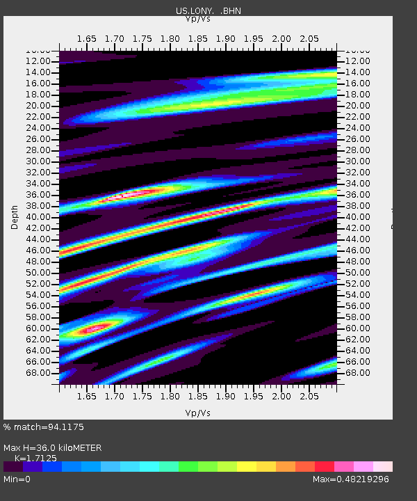
LONY Lake Ozonia, New York, USA - Earthquake Result Viewer
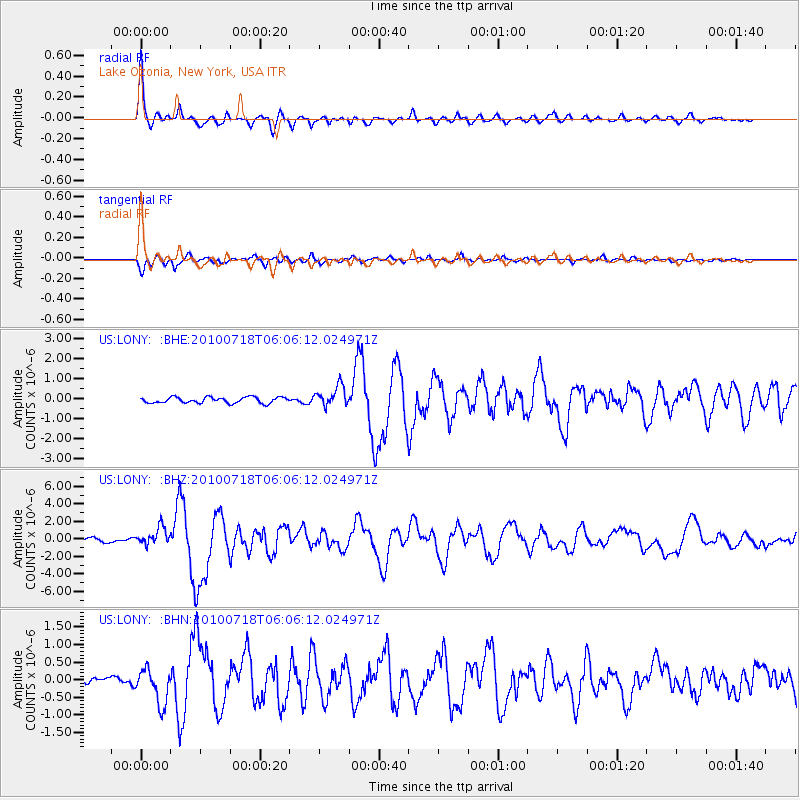
Earthquake location: Fox Islands, Aleutian Islands
Earthquake latitude/longitude: 52.9/-169.8
Earthquake time(UTC): 2010/07/18 (199) 05:56:44 GMT
Earthquake Depth: 14 km
Earthquake Magnitude: 6.3 MB, 6.7 MS, 6.6 MW, 6.6 MW
Earthquake Catalog/Contributor: WHDF/NEIC
Network: US United States National Seismic Network
Station: LONY Lake Ozonia, New York, USA
Lat/Lon: 44.62 N/74.58 W
Elevation: 440 m
Distance: 58.9 deg
Az: 56.181 deg
Baz: 315.16 deg
Ray Param: 0.06255641
Estimated Moho Depth: 36.0 km
Estimated Crust Vp/Vs: 1.71
Assumed Crust Vp: 6.419 km/s
Estimated Crust Vs: 3.748 km/s
Estimated Crust Poisson's Ratio: 0.24
Radial Match: 94.1175 %
Radial Bump: 350
Transverse Match: 87.689545 %
Transverse Bump: 400
SOD ConfigId: 319893
Insert Time: 2011-01-05 06:17:51.344 +0000
GWidth: 2.5
Max Bumps: 400
Tol: 0.001

Signal To Noise

ChannelStoNSTALTA
US:LONY: :BHZ:20100718T06:06:12.024971Z4.30144641.01639E-62.3629028E-7
US:LONY: :BHN:20100718T06:06:12.024971Z3.62057975.0068167E-71.382877E-7
US:LONY: :BHE:20100718T06:06:12.024971Z3.48980245.0927764E-71.459331E-7
Arrivals
Ps4.2 SECOND
PpPs14 SECOND
PsPs/PpSs19 SECOND