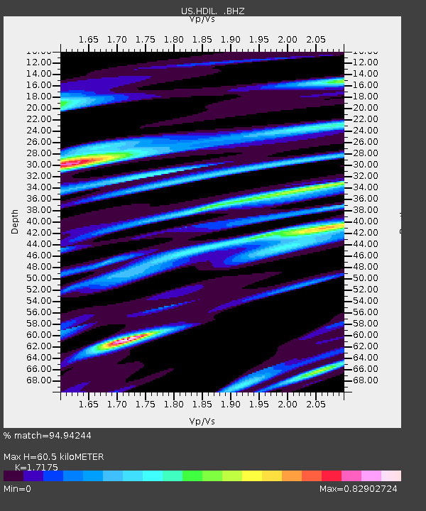
HDIL Hopedale, Illinois, USA - Earthquake Result Viewer
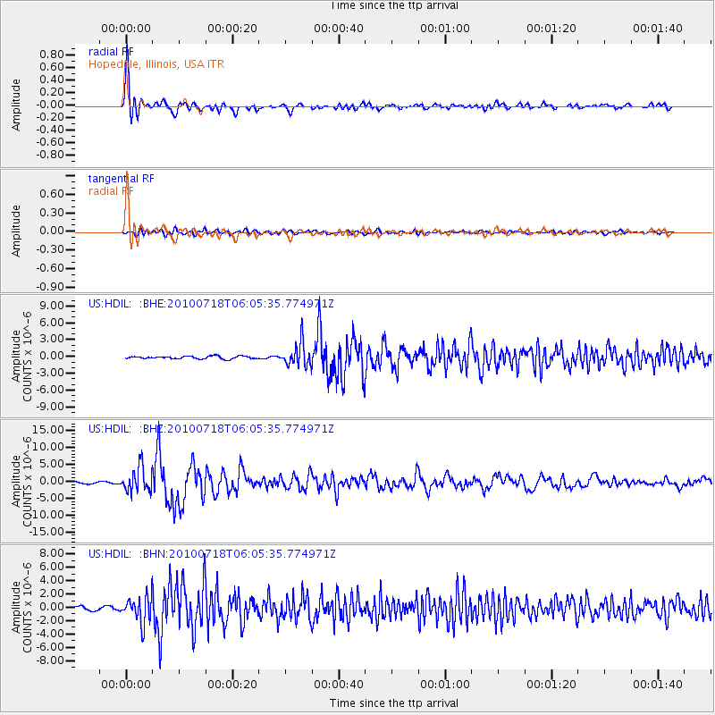
Earthquake location: Fox Islands, Aleutian Islands
Earthquake latitude/longitude: 52.9/-169.8
Earthquake time(UTC): 2010/07/18 (199) 05:56:44 GMT
Earthquake Depth: 14 km
Earthquake Magnitude: 6.3 MB, 6.7 MS, 6.6 MW, 6.6 MW
Earthquake Catalog/Contributor: WHDF/NEIC
Network: US United States National Seismic Network
Station: HDIL Hopedale, Illinois, USA
Lat/Lon: 40.56 N/89.29 W
Elevation: 219 m
Distance: 53.8 deg
Az: 68.695 deg
Baz: 312.171 deg
Ray Param: 0.06586273
Estimated Moho Depth: 60.5 km
Estimated Crust Vp/Vs: 1.72
Assumed Crust Vp: 6.498 km/s
Estimated Crust Vs: 3.783 km/s
Estimated Crust Poisson's Ratio: 0.24
Radial Match: 94.94244 %
Radial Bump: 400
Transverse Match: 79.99191 %
Transverse Bump: 400
SOD ConfigId: 319893
Insert Time: 2011-01-05 06:18:26.199 +0000
GWidth: 2.5
Max Bumps: 400
Tol: 0.001

Signal To Noise

ChannelStoNSTALTA
US:HDIL: :BHZ:20100718T06:05:35.774971Z15.38950353.5767948E-62.3241783E-7
US:HDIL: :BHN:20100718T06:05:35.774971Z8.6477171.9511647E-62.2562772E-7
US:HDIL: :BHE:20100718T06:05:35.774971Z8.7849912.0878076E-62.376562E-7
Arrivals
Ps7.1 SECOND
PpPs24 SECOND
PsPs/PpSs31 SECOND