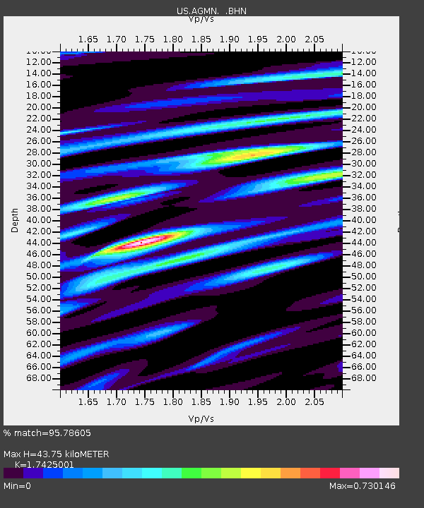
AGMN Agassiz National Wildlife Refuge, Minnesota, USA - Earthquake Result Viewer
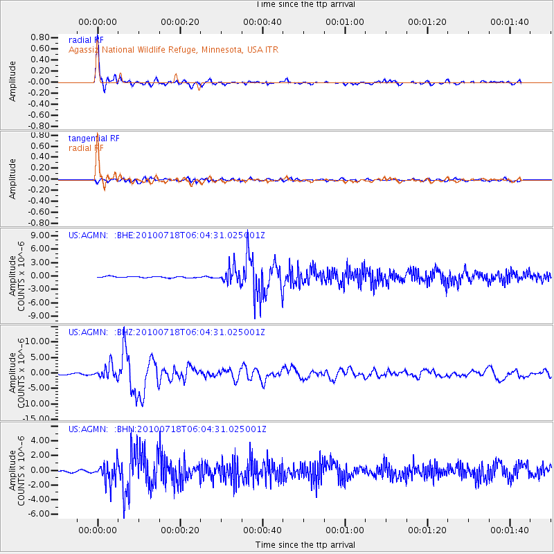
Earthquake location: Fox Islands, Aleutian Islands
Earthquake latitude/longitude: 52.9/-169.8
Earthquake time(UTC): 2010/07/18 (199) 05:56:44 GMT
Earthquake Depth: 14 km
Earthquake Magnitude: 6.3 MB, 6.7 MS, 6.6 MW, 6.6 MW
Earthquake Catalog/Contributor: WHDF/NEIC
Network: US United States National Seismic Network
Station: AGMN Agassiz National Wildlife Refuge, Minnesota, USA
Lat/Lon: 48.30 N/95.86 W
Elevation: 351 m
Distance: 45.3 deg
Az: 64.607 deg
Baz: 304.914 deg
Ray Param: 0.07137573
Estimated Moho Depth: 43.75 km
Estimated Crust Vp/Vs: 1.74
Assumed Crust Vp: 6.419 km/s
Estimated Crust Vs: 3.684 km/s
Estimated Crust Poisson's Ratio: 0.25
Radial Match: 95.78605 %
Radial Bump: 367
Transverse Match: 79.05165 %
Transverse Bump: 400
SOD ConfigId: 319893
Insert Time: 2011-01-05 06:18:38.206 +0000
GWidth: 2.5
Max Bumps: 400
Tol: 0.001

Signal To Noise

ChannelStoNSTALTA
US:AGMN: :BHZ:20100718T06:04:31.025001Z9.4247142.2032293E-62.3377147E-7
US:AGMN: :BHN:20100718T06:04:31.025001Z6.71975661.3181954E-61.9616714E-7
US:AGMN: :BHE:20100718T06:04:31.025001Z11.9721241.739574E-61.4530204E-7
Arrivals
Ps5.4 SECOND
PpPs18 SECOND
PsPs/PpSs23 SECOND