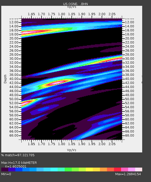
OGNE Ogallala, Nebraska, USA - Earthquake Result Viewer
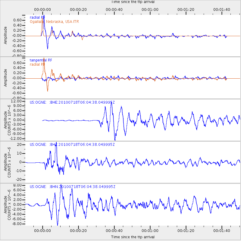
Earthquake location: Fox Islands, Aleutian Islands
Earthquake latitude/longitude: 52.9/-169.8
Earthquake time(UTC): 2010/07/18 (199) 05:56:44 GMT
Earthquake Depth: 14 km
Earthquake Magnitude: 6.3 MB, 6.7 MS, 6.6 MW, 6.6 MW
Earthquake Catalog/Contributor: WHDF/NEIC
Network: US United States National Seismic Network
Station: OGNE Ogallala, Nebraska, USA
Lat/Lon: 40.95 N/102.03 W
Elevation: 0.0 m
Distance: 46.2 deg
Az: 76.517 deg
Baz: 308.914 deg
Ray Param: 0.07080455
Estimated Moho Depth: 17.0 km
Estimated Crust Vp/Vs: 1.60
Assumed Crust Vp: 6.483 km/s
Estimated Crust Vs: 4.045 km/s
Estimated Crust Poisson's Ratio: 0.18
Radial Match: 97.321785 %
Radial Bump: 257
Transverse Match: 80.0218 %
Transverse Bump: 400
SOD ConfigId: 319893
Insert Time: 2011-01-05 06:18:46.147 +0000
GWidth: 2.5
Max Bumps: 400
Tol: 0.001

Signal To Noise

ChannelStoNSTALTA
US:OGNE: :BHZ:20100718T06:04:38.049995Z41.379625.0965573E-61.2316588E-7
US:OGNE: :BHN:20100718T06:04:38.049995Z3.56451541.5281834E-64.2872122E-7
US:OGNE: :BHE:20100718T06:04:38.049995Z15.7075832.268889E-61.4444545E-7
Arrivals
Ps1.7 SECOND
PpPs6.4 SECOND
PsPs/PpSs8.1 SECOND