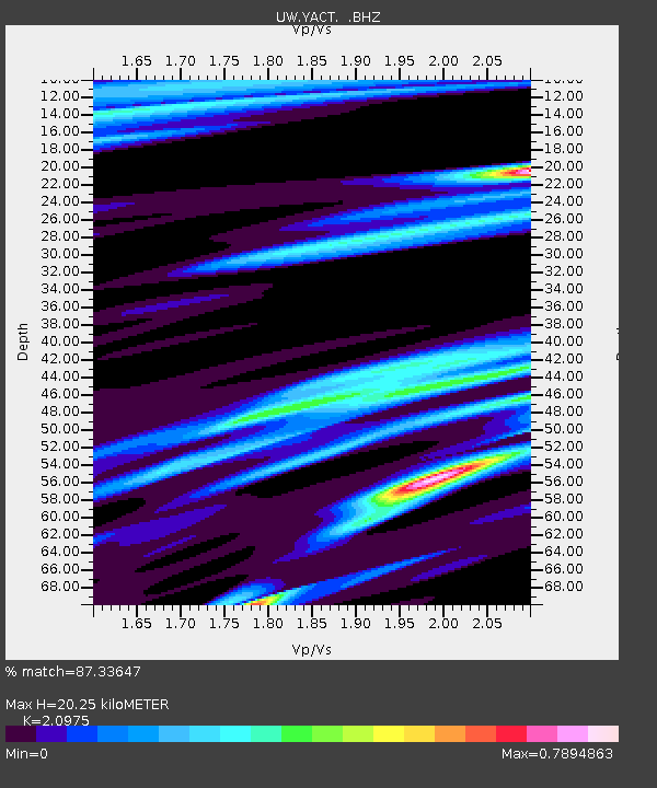
YACT Amboy, WA, USA - Earthquake Result Viewer
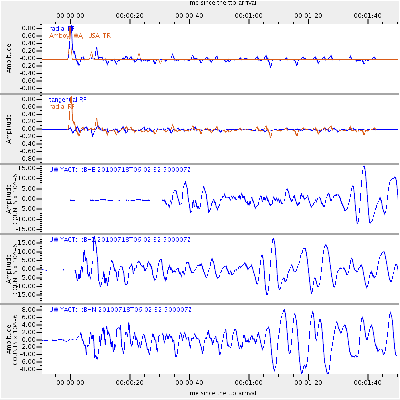
Earthquake location: Fox Islands, Aleutian Islands
Earthquake latitude/longitude: 52.9/-169.8
Earthquake time(UTC): 2010/07/18 (199) 05:56:44 GMT
Earthquake Depth: 14 km
Earthquake Magnitude: 6.3 MB, 6.7 MS, 6.6 MW, 6.6 MW
Earthquake Catalog/Contributor: WHDF/NEIC
Network: UW Pacific Northwest Regional Seismic Network
Station: YACT Amboy, WA, USA
Lat/Lon: 45.93 N/122.42 W
Elevation: 211 m
Distance: 31.2 deg
Az: 83.5 deg
Baz: 300.357 deg
Ray Param: 0.07913987
Estimated Moho Depth: 20.25 km
Estimated Crust Vp/Vs: 2.10
Assumed Crust Vp: 6.566 km/s
Estimated Crust Vs: 3.13 km/s
Estimated Crust Poisson's Ratio: 0.35
Radial Match: 87.33647 %
Radial Bump: 250
Transverse Match: 71.06123 %
Transverse Bump: 400
SOD ConfigId: 319893
Insert Time: 2011-01-05 06:18:57.201 +0000
GWidth: 2.5
Max Bumps: 400
Tol: 0.001

Signal To Noise

ChannelStoNSTALTA
UW:YACT: :BHZ:20100718T06:02:32.500007Z35.846323.8503877E-61.0741374E-7
UW:YACT: :BHN:20100718T06:02:32.500007Z4.51474437.5943154E-71.682114E-7
UW:YACT: :BHE:20100718T06:02:32.500007Z13.3748461.6009317E-61.196972E-7
Arrivals
Ps3.6 SECOND
PpPs8.9 SECOND
PsPs/PpSs13 SECOND