You are here: Home > Network List > UW - Pacific Northwest Regional Seismic Network Stations List
> Station MRBL Marblemount, WA, USA > Earthquake Result Viewer
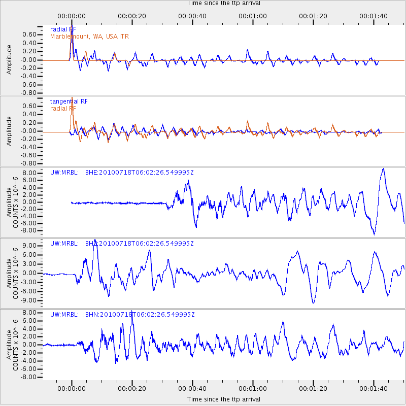
MRBL Marblemount, WA, USA - Earthquake Result Viewer
*The percent match for this event was below the threshold and hence no stack was calculated.
| Earthquake location: |
Fox Islands, Aleutian Islands |
| Earthquake latitude/longitude: |
52.9/-169.8 |
| Earthquake time(UTC): |
2010/07/18 (199) 05:56:44 GMT |
| Earthquake Depth: |
14 km |
| Earthquake Magnitude: |
6.3 MB, 6.7 MS, 6.6 MW, 6.6 MW |
| Earthquake Catalog/Contributor: |
WHDF/NEIC |
|
| Network: |
UW Pacific Northwest Regional Seismic Network |
| Station: |
MRBL Marblemount, WA, USA |
| Lat/Lon: |
48.52 N/121.48 W |
| Elevation: |
75 m |
|
| Distance: |
30.5 deg |
| Az: |
78.468 deg |
| Baz: |
296.719 deg |
| Ray Param: |
$rayparam |
*The percent match for this event was below the threshold and hence was not used in the summary stack. |
|
| Radial Match: |
77.968185 % |
| Radial Bump: |
316 |
| Transverse Match: |
73.33851 % |
| Transverse Bump: |
400 |
| SOD ConfigId: |
319893 |
| Insert Time: |
2011-01-05 06:18:58.456 +0000 |
| GWidth: |
2.5 |
| Max Bumps: |
400 |
| Tol: |
0.001 |
|
Signal To Noise
| Channel | StoN | STA | LTA |
| UW:MRBL: :BHZ:20100718T06:02:26.549995Z | 16.057983 | 2.1509259E-6 | 1.3394744E-7 |
| UW:MRBL: :BHN:20100718T06:02:26.549995Z | 5.5107403 | 6.5221263E-7 | 1.18353E-7 |
| UW:MRBL: :BHE:20100718T06:02:26.549995Z | 10.0782175 | 1.0485325E-6 | 1.0403948E-7 |
| Arrivals |
| Ps | |
| PpPs | |
| PsPs/PpSs | |


