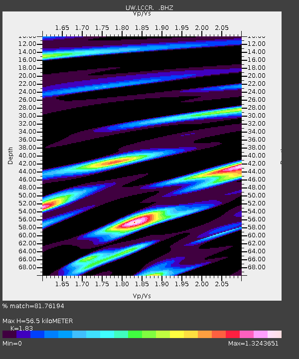
LCCR Mulino, OR, USA - Earthquake Result Viewer

Earthquake location: Fox Islands, Aleutian Islands
Earthquake latitude/longitude: 52.9/-169.8
Earthquake time(UTC): 2010/07/18 (199) 05:56:44 GMT
Earthquake Depth: 14 km
Earthquake Magnitude: 6.3 MB, 6.7 MS, 6.6 MW, 6.6 MW
Earthquake Catalog/Contributor: WHDF/NEIC
Network: UW Pacific Northwest Regional Seismic Network
Station: LCCR Mulino, OR, USA
Lat/Lon: 45.21 N/122.48 W
Elevation: 273 m
Distance: 31.5 deg
Az: 84.741 deg
Baz: 301.376 deg
Ray Param: 0.079047754
Estimated Moho Depth: 56.5 km
Estimated Crust Vp/Vs: 1.83
Assumed Crust Vp: 6.566 km/s
Estimated Crust Vs: 3.588 km/s
Estimated Crust Poisson's Ratio: 0.29
Radial Match: 81.76194 %
Radial Bump: 400
Transverse Match: 64.19208 %
Transverse Bump: 400
SOD ConfigId: 319893
Insert Time: 2011-01-05 06:19:21.992 +0000
GWidth: 2.5
Max Bumps: 400
Tol: 0.001

Signal To Noise

ChannelStoNSTALTA
UW:LCCR: :BHZ:20100718T06:02:35.475013Z17.769084.981944E-62.8037152E-7
UW:LCCR: :BHN:20100718T06:02:35.475013Z2.61318788.811447E-73.371915E-7
UW:LCCR: :BHE:20100718T06:02:35.475013Z6.00141051.8838301E-63.1389789E-7
Arrivals
Ps7.7 SECOND
PpPs22 SECOND
PsPs/PpSs30 SECOND