You are here: Home > Network List > AK - Alaska Regional Network Stations List
> Station CAST Castle Rocks > Earthquake Result Viewer
CAST Castle Rocks - Earthquake Result Viewer
| Earthquake location: |
Philippine Islands Region |
| Earthquake latitude/longitude: |
19.3/121.2 |
| Earthquake time(UTC): |
2023/09/12 (255) 11:03:18 GMT |
| Earthquake Depth: |
41 km |
| Earthquake Magnitude: |
6.3 Mww |
| Earthquake Catalog/Contributor: |
NEIC PDE/us |
|
| Network: |
AK Alaska Regional Network |
| Station: |
CAST Castle Rocks |
| Lat/Lon: |
63.42 N/152.08 W |
| Elevation: |
611 m |
|
| Distance: |
71.5 deg |
| Az: |
28.269 deg |
| Baz: |
275.993 deg |
| Ray Param: |
0.054229937 |
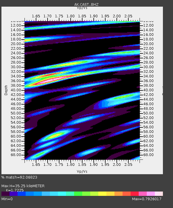
| Estimated Moho Depth: |
35.25 km |
| Estimated Crust Vp/Vs: |
1.72 |
| Assumed Crust Vp: |
6.566 km/s |
| Estimated Crust Vs: |
3.812 km/s |
| Estimated Crust Poisson's Ratio: |
0.25 |
|
| Radial Match: |
92.06823 % |
| Radial Bump: |
397 |
| Transverse Match: |
76.21794 % |
| Transverse Bump: |
400 |
| SOD ConfigId: |
31937991 |
| Insert Time: |
2023-09-26 11:06:22.934 +0000 |
| GWidth: |
2.5 |
| Max Bumps: |
400 |
| Tol: |
0.001 |
|

Signal To Noise
| Channel | StoN | STA | LTA |
| AK:CAST: :BHZ:20230912T11:14:04.388015Z | 31.270784 | 3.3675476E-6 | 1.076899E-7 |
| AK:CAST: :BHN:20230912T11:14:04.388015Z | 3.1891851 | 2.7083908E-7 | 8.4924224E-8 |
| AK:CAST: :BHE:20230912T11:14:04.388015Z | 17.040203 | 1.2471331E-6 | 7.3187685E-8 |
| Arrivals |
| Ps | 4.0 SECOND |
| PpPs | 14 SECOND |
| PsPs/PpSs | 18 SECOND |


