You are here: Home > Network List > AK - Alaska Regional Network Stations List
> Station D17K Noatak River, AK, USA > Earthquake Result Viewer
D17K Noatak River, AK, USA - Earthquake Result Viewer
| Earthquake location: |
Philippine Islands Region |
| Earthquake latitude/longitude: |
19.3/121.2 |
| Earthquake time(UTC): |
2023/09/12 (255) 11:03:18 GMT |
| Earthquake Depth: |
41 km |
| Earthquake Magnitude: |
6.3 Mww |
| Earthquake Catalog/Contributor: |
NEIC PDE/us |
|
| Network: |
AK Alaska Regional Network |
| Station: |
D17K Noatak River, AK, USA |
| Lat/Lon: |
67.70 N/163.08 W |
| Elevation: |
172 m |
|
| Distance: |
66.9 deg |
| Az: |
23.707 deg |
| Baz: |
264.355 deg |
| Ray Param: |
0.057228792 |
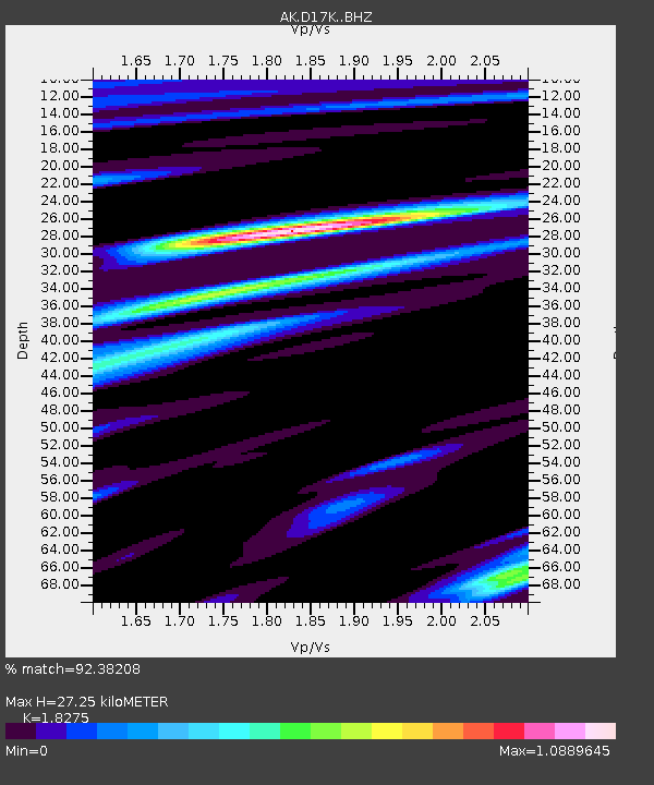
| Estimated Moho Depth: |
27.25 km |
| Estimated Crust Vp/Vs: |
1.83 |
| Assumed Crust Vp: |
6.276 km/s |
| Estimated Crust Vs: |
3.434 km/s |
| Estimated Crust Poisson's Ratio: |
0.29 |
|
| Radial Match: |
92.38208 % |
| Radial Bump: |
301 |
| Transverse Match: |
91.04121 % |
| Transverse Bump: |
400 |
| SOD ConfigId: |
31937991 |
| Insert Time: |
2023-09-26 11:06:34.452 +0000 |
| GWidth: |
2.5 |
| Max Bumps: |
400 |
| Tol: |
0.001 |
|

Signal To Noise
| Channel | StoN | STA | LTA |
| AK:D17K: :BHZ:20230912T11:13:36.07997Z | 71.768394 | 3.8191592E-6 | 5.3215057E-8 |
| AK:D17K: :BHN:20230912T11:13:36.07997Z | 8.567371 | 6.2740645E-7 | 7.323208E-8 |
| AK:D17K: :BHE:20230912T11:13:36.07997Z | 29.381128 | 1.3589264E-6 | 4.6251674E-8 |
| Arrivals |
| Ps | 3.7 SECOND |
| PpPs | 12 SECOND |
| PsPs/PpSs | 16 SECOND |


