You are here: Home > Network List > NM - Cooperative New Madrid Seismic Network Stations List
> Station LPAR Lepanto,AR > Earthquake Result Viewer
LPAR Lepanto,AR - Earthquake Result Viewer
| Earthquake location: |
Western Brazil |
| Earthquake latitude/longitude: |
-8.1/-71.6 |
| Earthquake time(UTC): |
2019/01/05 (005) 19:25:38 GMT |
| Earthquake Depth: |
575 km |
| Earthquake Magnitude: |
6.8 Mww |
| Earthquake Catalog/Contributor: |
NEIC PDE/us |
|
| Network: |
NM Cooperative New Madrid Seismic Network |
| Station: |
LPAR Lepanto,AR |
| Lat/Lon: |
35.60 N/90.30 W |
| Elevation: |
67 m |
|
| Distance: |
47.0 deg |
| Az: |
339.023 deg |
| Baz: |
154.22 deg |
| Ray Param: |
0.0675439 |
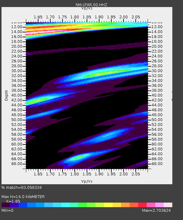
| Estimated Moho Depth: |
14.0 km |
| Estimated Crust Vp/Vs: |
1.65 |
| Assumed Crust Vp: |
6.273 km/s |
| Estimated Crust Vs: |
3.802 km/s |
| Estimated Crust Poisson's Ratio: |
0.21 |
|
| Radial Match: |
83.058334 % |
| Radial Bump: |
400 |
| Transverse Match: |
63.9473 % |
| Transverse Bump: |
400 |
| SOD ConfigId: |
3201911 |
| Insert Time: |
2019-01-19 19:38:33.914 +0000 |
| GWidth: |
2.5 |
| Max Bumps: |
400 |
| Tol: |
0.001 |
|

Signal To Noise
| Channel | StoN | STA | LTA |
| NM:LPAR:00:HHZ:20190105T19:32:47.789996Z | 78.87356 | 2.6370653E-5 | 3.3434085E-7 |
| NM:LPAR:00:HHN:20190105T19:32:47.789996Z | 25.786509 | 2.6944917E-5 | 1.044923E-6 |
| NM:LPAR:00:HHE:20190105T19:32:47.789996Z | 12.791331 | 1.4165435E-5 | 1.1074246E-6 |
| Arrivals |
| Ps | 1.5 SECOND |
| PpPs | 5.6 SECOND |
| PsPs/PpSs | 7.1 SECOND |


