You are here: Home > Network List > AK - Alaska Regional Network Stations List
> Station M14K Bethel, AK, USA > Earthquake Result Viewer
M14K Bethel, AK, USA - Earthquake Result Viewer
| Earthquake location: |
Philippine Islands Region |
| Earthquake latitude/longitude: |
19.3/121.2 |
| Earthquake time(UTC): |
2023/09/12 (255) 11:03:18 GMT |
| Earthquake Depth: |
41 km |
| Earthquake Magnitude: |
6.3 Mww |
| Earthquake Catalog/Contributor: |
NEIC PDE/us |
|
| Network: |
AK Alaska Regional Network |
| Station: |
M14K Bethel, AK, USA |
| Lat/Lon: |
60.75 N/161.96 W |
| Elevation: |
19 m |
|
| Distance: |
67.0 deg |
| Az: |
31.309 deg |
| Baz: |
268.349 deg |
| Ray Param: |
0.05719849 |
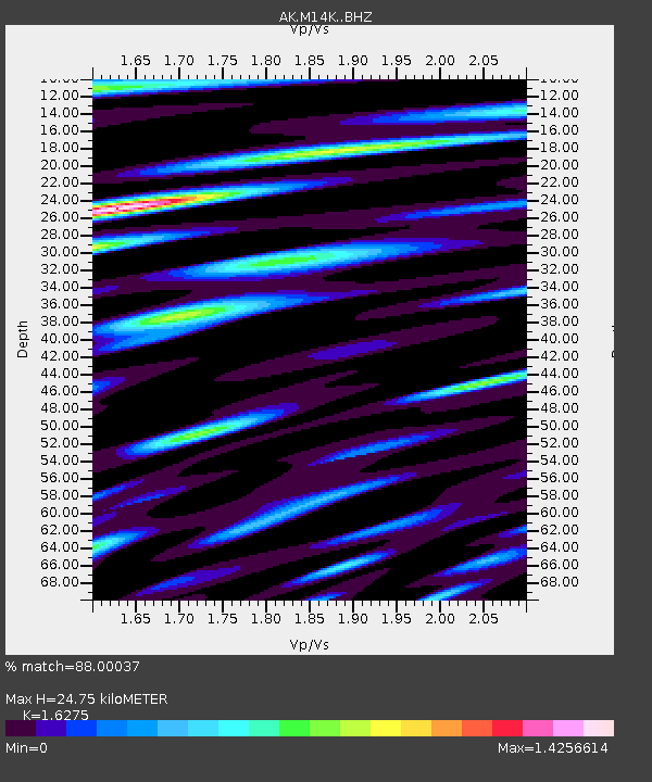
| Estimated Moho Depth: |
24.75 km |
| Estimated Crust Vp/Vs: |
1.63 |
| Assumed Crust Vp: |
6.182 km/s |
| Estimated Crust Vs: |
3.799 km/s |
| Estimated Crust Poisson's Ratio: |
0.20 |
|
| Radial Match: |
88.00037 % |
| Radial Bump: |
394 |
| Transverse Match: |
78.04656 % |
| Transverse Bump: |
400 |
| SOD ConfigId: |
31937991 |
| Insert Time: |
2023-09-26 11:08:14.357 +0000 |
| GWidth: |
2.5 |
| Max Bumps: |
400 |
| Tol: |
0.001 |
|

Signal To Noise
| Channel | StoN | STA | LTA |
| AK:M14K: :BHZ:20230912T11:13:36.380019Z | 23.402374 | 3.3867116E-6 | 1.4471658E-7 |
| AK:M14K: :BHN:20230912T11:13:36.380019Z | 1.5979545 | 5.929493E-7 | 3.7106767E-7 |
| AK:M14K: :BHE:20230912T11:13:36.380019Z | 4.7146053 | 1.1991613E-6 | 2.5435028E-7 |
| Arrivals |
| Ps | 2.6 SECOND |
| PpPs | 10 SECOND |
| PsPs/PpSs | 13 SECOND |


