You are here: Home > Network List > AK - Alaska Regional Network Stations List
> Station O18K Koktuh Hills, AK, USA > Earthquake Result Viewer
O18K Koktuh Hills, AK, USA - Earthquake Result Viewer
| Earthquake location: |
Philippine Islands Region |
| Earthquake latitude/longitude: |
19.3/121.2 |
| Earthquake time(UTC): |
2023/09/12 (255) 11:03:18 GMT |
| Earthquake Depth: |
41 km |
| Earthquake Magnitude: |
6.3 Mww |
| Earthquake Catalog/Contributor: |
NEIC PDE/us |
|
| Network: |
AK Alaska Regional Network |
| Station: |
O18K Koktuh Hills, AK, USA |
| Lat/Lon: |
59.85 N/155.21 W |
| Elevation: |
544 m |
|
| Distance: |
70.3 deg |
| Az: |
32.183 deg |
| Baz: |
274.525 deg |
| Ray Param: |
0.054994974 |
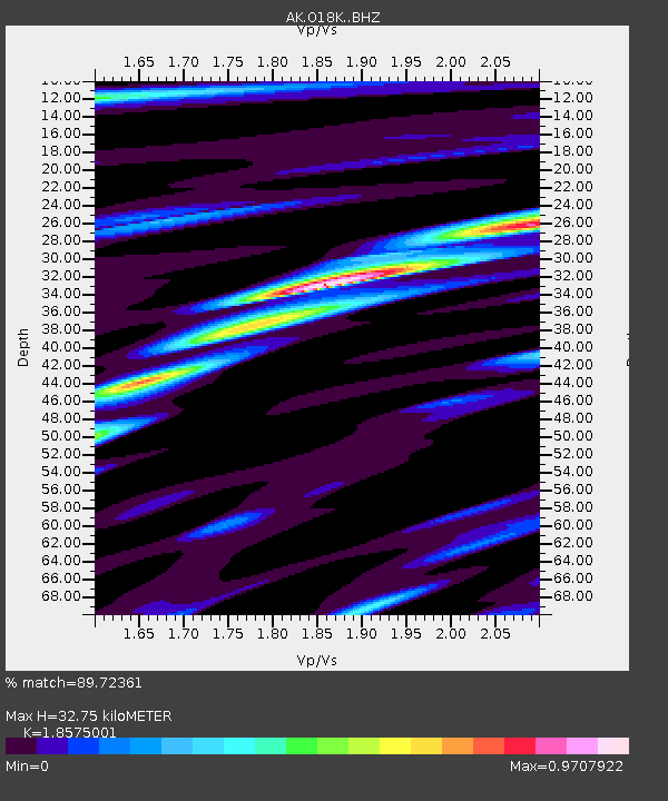
| Estimated Moho Depth: |
32.75 km |
| Estimated Crust Vp/Vs: |
1.86 |
| Assumed Crust Vp: |
6.438 km/s |
| Estimated Crust Vs: |
3.466 km/s |
| Estimated Crust Poisson's Ratio: |
0.30 |
|
| Radial Match: |
89.72361 % |
| Radial Bump: |
304 |
| Transverse Match: |
87.95781 % |
| Transverse Bump: |
330 |
| SOD ConfigId: |
31937991 |
| Insert Time: |
2023-09-26 11:08:37.121 +0000 |
| GWidth: |
2.5 |
| Max Bumps: |
400 |
| Tol: |
0.001 |
|

Signal To Noise
| Channel | StoN | STA | LTA |
| AK:O18K: :BHZ:20230912T11:13:57.399978Z | 49.63401 | 5.400002E-6 | 1.087964E-7 |
| AK:O18K: :BHN:20230912T11:13:57.399978Z | 6.9280453 | 5.7782665E-7 | 8.3404E-8 |
| AK:O18K: :BHE:20230912T11:13:57.399978Z | 14.477746 | 1.7979371E-6 | 1.2418626E-7 |
| Arrivals |
| Ps | 4.5 SECOND |
| PpPs | 14 SECOND |
| PsPs/PpSs | 19 SECOND |


