You are here: Home > Network List > AK - Alaska Regional Network Stations List
> Station PS07 TAPS Pump Station 7, AK, USA > Earthquake Result Viewer
PS07 TAPS Pump Station 7, AK, USA - Earthquake Result Viewer
| Earthquake location: |
Philippine Islands Region |
| Earthquake latitude/longitude: |
19.3/121.2 |
| Earthquake time(UTC): |
2023/09/12 (255) 11:03:18 GMT |
| Earthquake Depth: |
41 km |
| Earthquake Magnitude: |
6.3 Mww |
| Earthquake Catalog/Contributor: |
NEIC PDE/us |
|
| Network: |
AK Alaska Regional Network |
| Station: |
PS07 TAPS Pump Station 7, AK, USA |
| Lat/Lon: |
65.31 N/148.28 W |
| Elevation: |
289 m |
|
| Distance: |
72.9 deg |
| Az: |
26.069 deg |
| Baz: |
278.745 deg |
| Ray Param: |
0.053302776 |
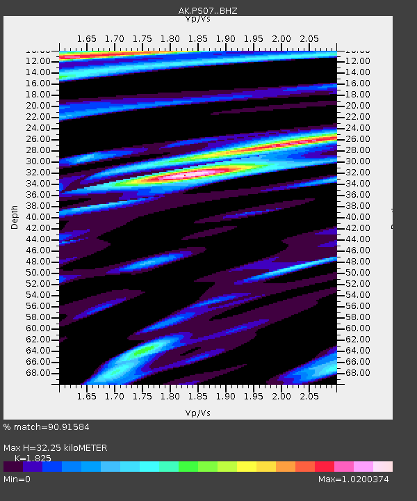
| Estimated Moho Depth: |
32.25 km |
| Estimated Crust Vp/Vs: |
1.83 |
| Assumed Crust Vp: |
6.566 km/s |
| Estimated Crust Vs: |
3.598 km/s |
| Estimated Crust Poisson's Ratio: |
0.29 |
|
| Radial Match: |
90.91584 % |
| Radial Bump: |
319 |
| Transverse Match: |
86.34726 % |
| Transverse Bump: |
400 |
| SOD ConfigId: |
31937991 |
| Insert Time: |
2023-09-26 11:08:56.838 +0000 |
| GWidth: |
2.5 |
| Max Bumps: |
400 |
| Tol: |
0.001 |
|

Signal To Noise
| Channel | StoN | STA | LTA |
| AK:PS07: :BHZ:20230912T11:14:12.72798Z | 39.113 | 4.1211442E-6 | 1.05365075E-7 |
| AK:PS07: :BHN:20230912T11:14:12.72798Z | 4.877187 | 4.310559E-7 | 8.838207E-8 |
| AK:PS07: :BHE:20230912T11:14:12.72798Z | 7.619101 | 1.1069908E-6 | 1.4529152E-7 |
| Arrivals |
| Ps | 4.2 SECOND |
| PpPs | 13 SECOND |
| PsPs/PpSs | 18 SECOND |


