You are here: Home > Network List > AK - Alaska Regional Network Stations List
> Station WAT6 Susitna Watana 6, AK, USA > Earthquake Result Viewer
WAT6 Susitna Watana 6, AK, USA - Earthquake Result Viewer
| Earthquake location: |
Philippine Islands Region |
| Earthquake latitude/longitude: |
19.3/121.2 |
| Earthquake time(UTC): |
2023/09/12 (255) 11:03:18 GMT |
| Earthquake Depth: |
41 km |
| Earthquake Magnitude: |
6.3 Mww |
| Earthquake Catalog/Contributor: |
NEIC PDE/us |
|
| Network: |
AK Alaska Regional Network |
| Station: |
WAT6 Susitna Watana 6, AK, USA |
| Lat/Lon: |
62.58 N/147.74 W |
| Elevation: |
1681 m |
|
| Distance: |
73.6 deg |
| Az: |
28.853 deg |
| Baz: |
280.032 deg |
| Ray Param: |
0.052844856 |
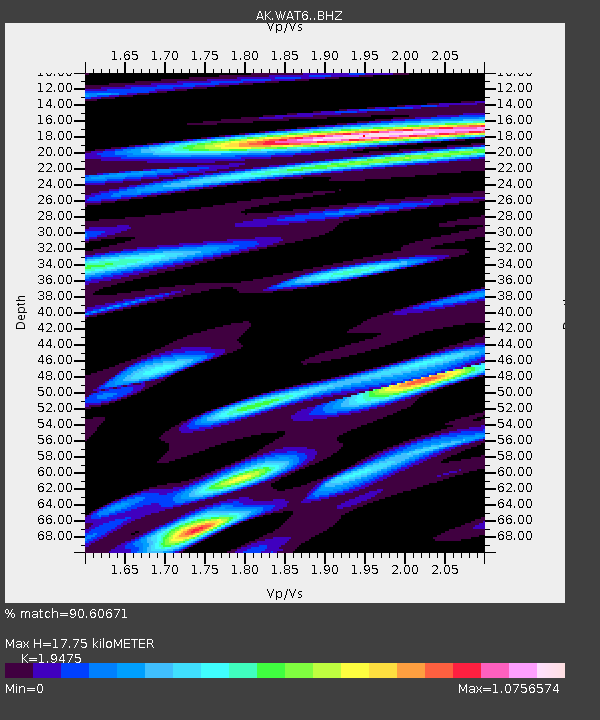
| Estimated Moho Depth: |
17.75 km |
| Estimated Crust Vp/Vs: |
1.95 |
| Assumed Crust Vp: |
6.566 km/s |
| Estimated Crust Vs: |
3.372 km/s |
| Estimated Crust Poisson's Ratio: |
0.32 |
|
| Radial Match: |
90.60671 % |
| Radial Bump: |
400 |
| Transverse Match: |
79.7986 % |
| Transverse Bump: |
400 |
| SOD ConfigId: |
31937991 |
| Insert Time: |
2023-09-26 11:09:35.971 +0000 |
| GWidth: |
2.5 |
| Max Bumps: |
400 |
| Tol: |
0.001 |
|

Signal To Noise
| Channel | StoN | STA | LTA |
| AK:WAT6: :BHZ:20230912T11:14:16.72798Z | 40.610085 | 3.1469997E-6 | 7.7493056E-8 |
| AK:WAT6: :BHN:20230912T11:14:16.72798Z | 5.559601 | 4.6993532E-7 | 8.452681E-8 |
| AK:WAT6: :BHE:20230912T11:14:16.72798Z | 16.120773 | 1.6365989E-6 | 1.01521124E-7 |
| Arrivals |
| Ps | 2.6 SECOND |
| PpPs | 7.7 SECOND |
| PsPs/PpSs | 10 SECOND |


