You are here: Home > Network List > AU - Australian Seismological Centre Stations List
> Station KIM08 GSWA station > Earthquake Result Viewer
KIM08 GSWA station - Earthquake Result Viewer
| Earthquake location: |
Philippine Islands Region |
| Earthquake latitude/longitude: |
19.3/121.2 |
| Earthquake time(UTC): |
2023/09/12 (255) 11:03:18 GMT |
| Earthquake Depth: |
41 km |
| Earthquake Magnitude: |
6.3 Mww |
| Earthquake Catalog/Contributor: |
NEIC PDE/us |
|
| Network: |
AU Australian Seismological Centre |
| Station: |
KIM08 GSWA station |
| Lat/Lon: |
17.32 S/124.81 E |
| Elevation: |
120 m |
|
| Distance: |
36.5 deg |
| Az: |
174.234 deg |
| Baz: |
354.297 deg |
| Ray Param: |
0.07656699 |
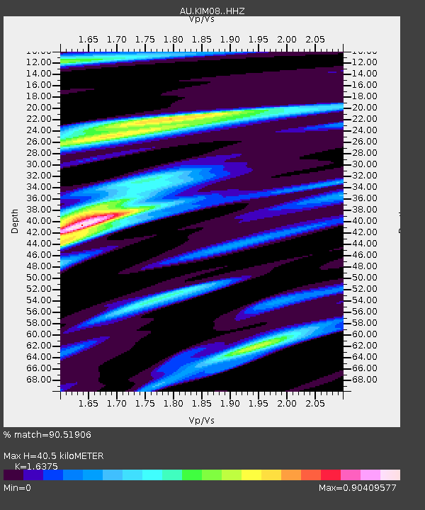
| Estimated Moho Depth: |
40.5 km |
| Estimated Crust Vp/Vs: |
1.64 |
| Assumed Crust Vp: |
6.496 km/s |
| Estimated Crust Vs: |
3.967 km/s |
| Estimated Crust Poisson's Ratio: |
0.20 |
|
| Radial Match: |
90.51906 % |
| Radial Bump: |
267 |
| Transverse Match: |
75.562675 % |
| Transverse Bump: |
400 |
| SOD ConfigId: |
31937991 |
| Insert Time: |
2023-09-26 11:10:26.440 +0000 |
| GWidth: |
2.5 |
| Max Bumps: |
400 |
| Tol: |
0.001 |
|

Signal To Noise
| Channel | StoN | STA | LTA |
| AU:KIM08: :HHZ:20230912T11:09:50.110Z | 36.12938 | 2.097708E-5 | 5.8061005E-7 |
| AU:KIM08: :HHN:20230912T11:09:50.110Z | 26.878855 | 1.3616494E-5 | 5.065876E-7 |
| AU:KIM08: :HHE:20230912T11:09:50.110Z | 2.4362836 | 1.9094693E-6 | 7.8376326E-7 |
| Arrivals |
| Ps | 4.3 SECOND |
| PpPs | 15 SECOND |
| PsPs/PpSs | 19 SECOND |


