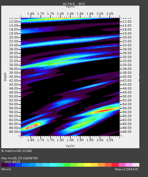
FALS False Pass - Earthquake Result Viewer

Earthquake location: New Britain Region, P.N.G.
Earthquake latitude/longitude: -6.0/150.4
Earthquake time(UTC): 2010/07/18 (199) 13:04:09 GMT
Earthquake Depth: 28 km
Earthquake Magnitude: 6.3 MB, 7.1 MS, 6.9 MW, 6.8 MW
Earthquake Catalog/Contributor: WHDF/NEIC
Network: AK Alaska Regional Network
Station: FALS False Pass
Lat/Lon: 54.86 N/163.42 W
Elevation: 46 m
Distance: 71.7 deg
Az: 26.056 deg
Baz: 229.08 deg
Ray Param: 0.05412062
Estimated Moho Depth: 65.25 km
Estimated Crust Vp/Vs: 1.65
Assumed Crust Vp: 5.989 km/s
Estimated Crust Vs: 3.624 km/s
Estimated Crust Poisson's Ratio: 0.21
Radial Match: 89.31568 %
Radial Bump: 400
Transverse Match: 79.868805 %
Transverse Bump: 400
SOD ConfigId: 319893
Insert Time: 2011-01-05 06:22:28.295 +0000
GWidth: 2.5
Max Bumps: 400
Tol: 0.001

Signal To Noise

ChannelStoNSTALTA
AK:FALS: :BHZ:20100718T13:14:57.607998Z20.6923072.0073646E-69.7010194E-8
AK:FALS: :BHN:20100718T13:14:57.607998Z2.5069079.695651E-73.8675753E-7
AK:FALS: :BHE:20100718T13:14:57.607998Z2.6263271.5078377E-65.7412416E-7
Arrivals
Ps7.3 SECOND
PpPs28 SECOND
PsPs/PpSs35 SECOND