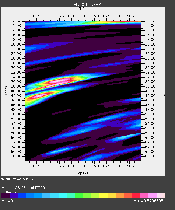
COLD Coldfoot Broadband - Earthquake Result Viewer
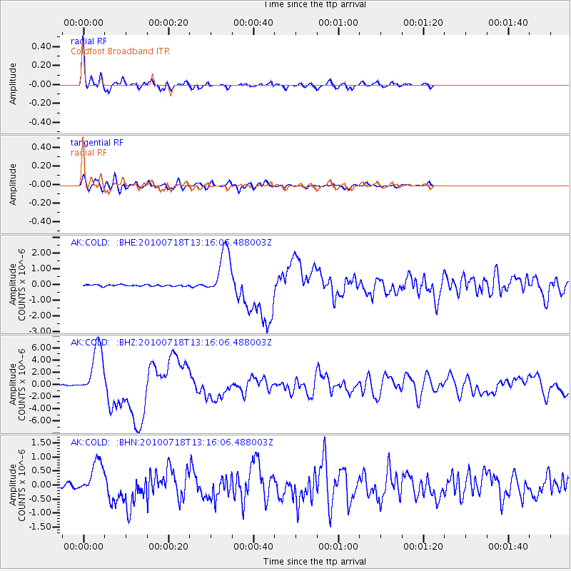
Earthquake location: New Britain Region, P.N.G.
Earthquake latitude/longitude: -6.0/150.4
Earthquake time(UTC): 2010/07/18 (199) 13:04:09 GMT
Earthquake Depth: 28 km
Earthquake Magnitude: 6.3 MB, 7.1 MS, 6.9 MW, 6.8 MW
Earthquake Catalog/Contributor: WHDF/NEIC
Network: AK Alaska Regional Network
Station: COLD Coldfoot Broadband
Lat/Lon: 67.23 N/150.20 W
Elevation: 377 m
Distance: 84.1 deg
Az: 19.678 deg
Baz: 239.36 deg
Ray Param: 0.045662407
Estimated Moho Depth: 35.25 km
Estimated Crust Vp/Vs: 1.75
Assumed Crust Vp: 6.577 km/s
Estimated Crust Vs: 3.758 km/s
Estimated Crust Poisson's Ratio: 0.26
Radial Match: 95.63631 %
Radial Bump: 392
Transverse Match: 84.37019 %
Transverse Bump: 400
SOD ConfigId: 319893
Insert Time: 2011-01-05 06:22:35.206 +0000
GWidth: 2.5
Max Bumps: 400
Tol: 0.001

Signal To Noise

ChannelStoNSTALTA
AK:COLD: :BHZ:20100718T13:16:06.488003Z61.6033174.3006503E-66.981199E-8
AK:COLD: :BHN:20100718T13:16:06.488003Z12.4912136.268117E-75.018021E-8
AK:COLD: :BHE:20100718T13:16:06.488003Z32.4321.5348937E-64.732652E-8
Arrivals
Ps4.1 SECOND
PpPs14 SECOND
PsPs/PpSs18 SECOND