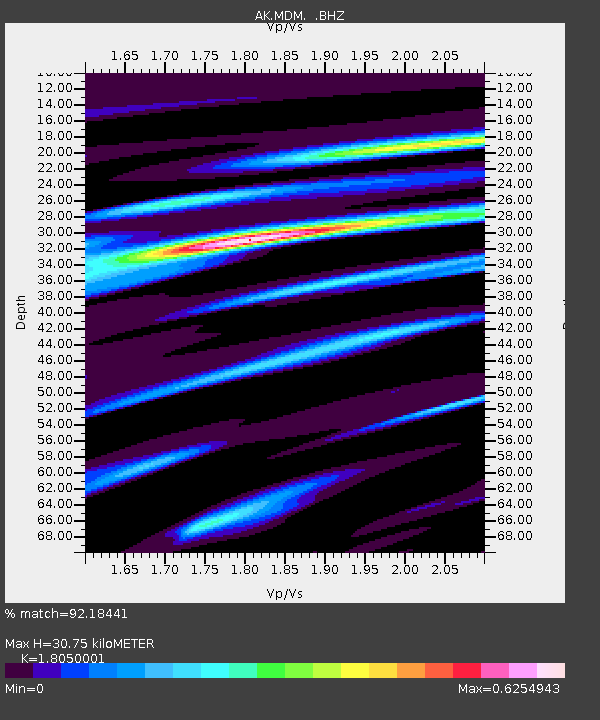
MDM Murphy Dome - Earthquake Result Viewer
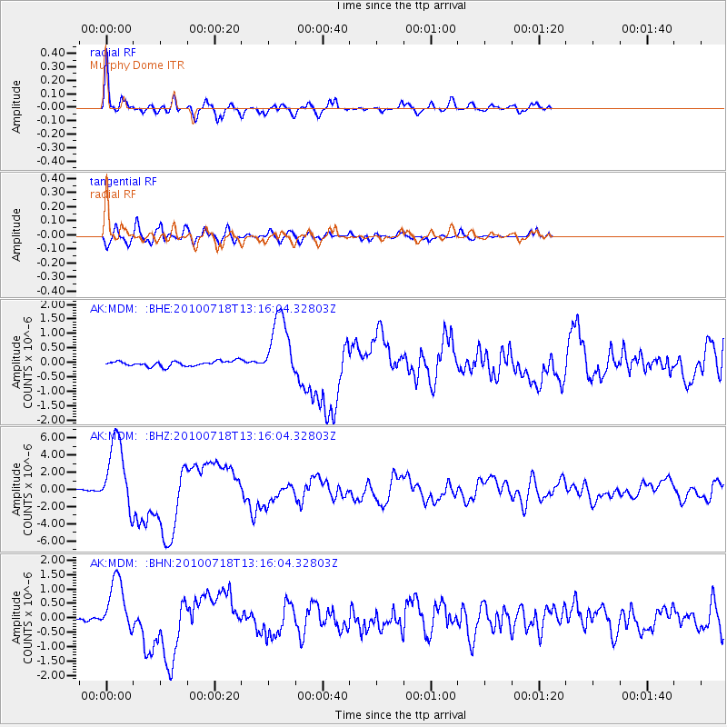
Earthquake location: New Britain Region, P.N.G.
Earthquake latitude/longitude: -6.0/150.4
Earthquake time(UTC): 2010/07/18 (199) 13:04:09 GMT
Earthquake Depth: 28 km
Earthquake Magnitude: 6.3 MB, 7.1 MS, 6.9 MW, 6.8 MW
Earthquake Catalog/Contributor: WHDF/NEIC
Network: AK Alaska Regional Network
Station: MDM Murphy Dome
Lat/Lon: 64.96 N/148.23 W
Elevation: 634 m
Distance: 83.7 deg
Az: 22.07 deg
Baz: 241.414 deg
Ray Param: 0.04596145
Estimated Moho Depth: 30.75 km
Estimated Crust Vp/Vs: 1.81
Assumed Crust Vp: 6.566 km/s
Estimated Crust Vs: 3.638 km/s
Estimated Crust Poisson's Ratio: 0.28
Radial Match: 92.18441 %
Radial Bump: 400
Transverse Match: 79.422005 %
Transverse Bump: 400
SOD ConfigId: 319893
Insert Time: 2011-01-05 06:22:46.552 +0000
GWidth: 2.5
Max Bumps: 400
Tol: 0.001

Signal To Noise

ChannelStoNSTALTA
AK:MDM: :BHZ:20100718T13:16:04.32803Z60.7966774.216735E-66.935799E-8
AK:MDM: :BHN:20100718T13:16:04.32803Z16.593449.4505134E-75.6953308E-8
AK:MDM: :BHE:20100718T13:16:04.32803Z12.8486351.138835E-68.8634714E-8
Arrivals
Ps3.9 SECOND
PpPs13 SECOND
PsPs/PpSs17 SECOND