You are here: Home > Network List > AV - Alaska Volcano Observatory Stations List
> Station ILNE Iliamna Northeast, Iliamna, Alaska > Earthquake Result Viewer
ILNE Iliamna Northeast, Iliamna, Alaska - Earthquake Result Viewer
| Earthquake location: |
Philippine Islands Region |
| Earthquake latitude/longitude: |
19.3/121.2 |
| Earthquake time(UTC): |
2023/09/12 (255) 11:03:18 GMT |
| Earthquake Depth: |
41 km |
| Earthquake Magnitude: |
6.3 Mww |
| Earthquake Catalog/Contributor: |
NEIC PDE/us |
|
| Network: |
AV Alaska Volcano Observatory |
| Station: |
ILNE Iliamna Northeast, Iliamna, Alaska |
| Lat/Lon: |
60.06 N/153.06 W |
| Elevation: |
1614 m |
|
| Distance: |
71.4 deg |
| Az: |
31.861 deg |
| Baz: |
276.273 deg |
| Ray Param: |
0.054298088 |
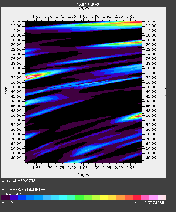
| Estimated Moho Depth: |
33.75 km |
| Estimated Crust Vp/Vs: |
1.61 |
| Assumed Crust Vp: |
6.566 km/s |
| Estimated Crust Vs: |
4.091 km/s |
| Estimated Crust Poisson's Ratio: |
0.18 |
|
| Radial Match: |
80.0753 % |
| Radial Bump: |
400 |
| Transverse Match: |
80.59911 % |
| Transverse Bump: |
400 |
| SOD ConfigId: |
31937991 |
| Insert Time: |
2023-09-26 11:12:46.817 +0000 |
| GWidth: |
2.5 |
| Max Bumps: |
400 |
| Tol: |
0.001 |
|

Signal To Noise
| Channel | StoN | STA | LTA |
| AV:ILNE: :BHZ:20230912T11:14:03.779982Z | 11.1847725 | 1.7397199E-6 | 1.5554362E-7 |
| AV:ILNE: :BHN:20230912T11:14:03.779982Z | 7.588968 | 1.2527373E-6 | 1.6507349E-7 |
| AV:ILNE: :BHE:20230912T11:14:03.779982Z | 5.915214 | 9.072056E-7 | 1.5336818E-7 |
| Arrivals |
| Ps | 3.2 SECOND |
| PpPs | 13 SECOND |
| PsPs/PpSs | 16 SECOND |


