You are here: Home > Network List > AV - Alaska Volcano Observatory Stations List
> Station KABU KABU - Katmai Volcanic Cluster, Alaska > Earthquake Result Viewer
KABU KABU - Katmai Volcanic Cluster, Alaska - Earthquake Result Viewer
| Earthquake location: |
Philippine Islands Region |
| Earthquake latitude/longitude: |
19.3/121.2 |
| Earthquake time(UTC): |
2023/09/12 (255) 11:03:18 GMT |
| Earthquake Depth: |
41 km |
| Earthquake Magnitude: |
6.3 Mww |
| Earthquake Catalog/Contributor: |
NEIC PDE/us |
|
| Network: |
AV Alaska Volcano Observatory |
| Station: |
KABU KABU - Katmai Volcanic Cluster, Alaska |
| Lat/Lon: |
58.27 N/155.28 W |
| Elevation: |
1065 m |
|
| Distance: |
70.4 deg |
| Az: |
33.867 deg |
| Baz: |
275.027 deg |
| Ray Param: |
0.054931622 |
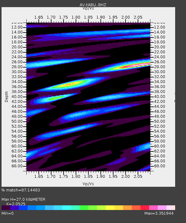
| Estimated Moho Depth: |
27.0 km |
| Estimated Crust Vp/Vs: |
2.05 |
| Assumed Crust Vp: |
6.438 km/s |
| Estimated Crust Vs: |
3.137 km/s |
| Estimated Crust Poisson's Ratio: |
0.34 |
|
| Radial Match: |
87.14483 % |
| Radial Bump: |
400 |
| Transverse Match: |
83.19424 % |
| Transverse Bump: |
400 |
| SOD ConfigId: |
31937991 |
| Insert Time: |
2023-09-26 11:12:57.346 +0000 |
| GWidth: |
2.5 |
| Max Bumps: |
400 |
| Tol: |
0.001 |
|

Signal To Noise
| Channel | StoN | STA | LTA |
| AV:KABU: :BHZ:20230912T11:13:57.948012Z | 14.280601 | 2.9973858E-6 | 2.0989214E-7 |
| AV:KABU: :BHN:20230912T11:13:57.948012Z | 8.805206 | 1.6231003E-6 | 1.8433417E-7 |
| AV:KABU: :BHE:20230912T11:13:57.948012Z | 14.137227 | 2.6770444E-6 | 1.8936136E-7 |
| Arrivals |
| Ps | 4.6 SECOND |
| PpPs | 12 SECOND |
| PsPs/PpSs | 17 SECOND |


