You are here: Home > Network List > AR - Northern Arizona Network Stations List
> Station W13A Hualapai Mountain Park, Kingman, AZ, USA > Earthquake Result Viewer
W13A Hualapai Mountain Park, Kingman, AZ, USA - Earthquake Result Viewer
| Earthquake location: |
New Britain Region, P.N.G. |
| Earthquake latitude/longitude: |
-6.0/150.4 |
| Earthquake time(UTC): |
2010/07/18 (199) 13:04:09 GMT |
| Earthquake Depth: |
28 km |
| Earthquake Magnitude: |
6.3 MB, 7.1 MS, 6.9 MW, 6.8 MW |
| Earthquake Catalog/Contributor: |
WHDF/NEIC |
|
| Network: |
AR Northern Arizona Network |
| Station: |
W13A Hualapai Mountain Park, Kingman, AZ, USA |
| Lat/Lon: |
35.10 N/113.89 W |
| Elevation: |
1988 m |
|
| Distance: |
98.0 deg |
| Az: |
55.491 deg |
| Baz: |
268.365 deg |
| Ray Param: |
0.040013935 |
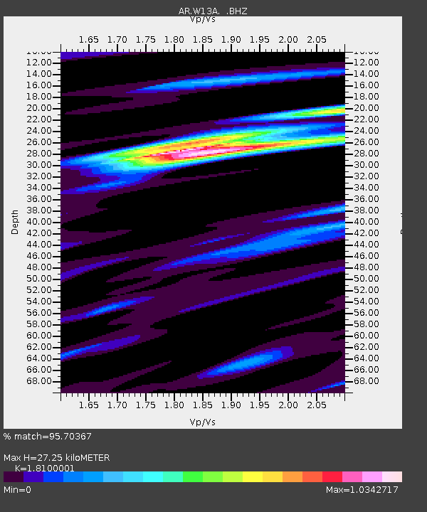
| Estimated Moho Depth: |
27.25 km |
| Estimated Crust Vp/Vs: |
1.81 |
| Assumed Crust Vp: |
6.276 km/s |
| Estimated Crust Vs: |
3.467 km/s |
| Estimated Crust Poisson's Ratio: |
0.28 |
|
| Radial Match: |
95.70367 % |
| Radial Bump: |
400 |
| Transverse Match: |
86.673164 % |
| Transverse Bump: |
400 |
| SOD ConfigId: |
319893 |
| Insert Time: |
2011-01-05 06:23:19.690 +0000 |
| GWidth: |
2.5 |
| Max Bumps: |
400 |
| Tol: |
0.001 |
|

Signal To Noise
| Channel | StoN | STA | LTA |
| AR:W13A: :BHZ:20100718T13:17:11.475002Z | 15.88966 | 9.395116E-7 | 5.912723E-8 |
| AR:W13A: :BHN:20100718T13:17:11.475002Z | 0.9861686 | 4.8641866E-8 | 4.9324083E-8 |
| AR:W13A: :BHE:20100718T13:17:11.475002Z | 6.4592237 | 3.014369E-7 | 4.6667665E-8 |
| Arrivals |
| Ps | 3.6 SECOND |
| PpPs | 12 SECOND |
| PsPs/PpSs | 16 SECOND |


