You are here: Home > Network List > AV - Alaska Volcano Observatory Stations List
> Station MAPS Pakushin Southeast, Makushin Volcano, Alaska > Earthquake Result Viewer
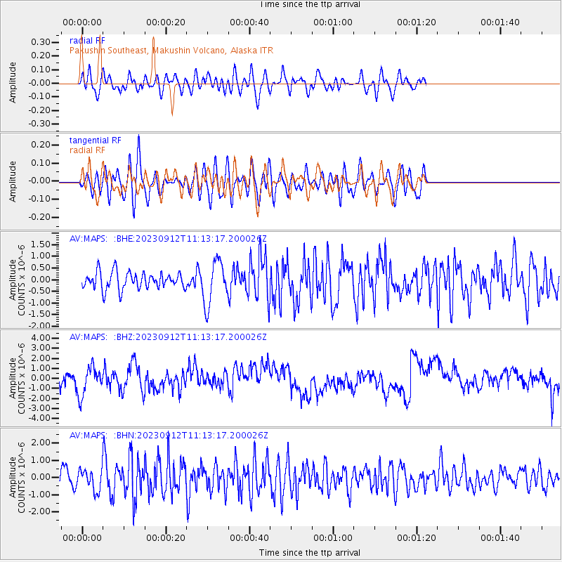
MAPS Pakushin Southeast, Makushin Volcano, Alaska - Earthquake Result Viewer
*The percent match for this event was below the threshold and hence no stack was calculated.
| Earthquake location: |
Philippine Islands Region |
| Earthquake latitude/longitude: |
19.3/121.2 |
| Earthquake time(UTC): |
2023/09/12 (255) 11:03:18 GMT |
| Earthquake Depth: |
41 km |
| Earthquake Magnitude: |
6.3 Mww |
| Earthquake Catalog/Contributor: |
NEIC PDE/us |
|
| Network: |
AV Alaska Volcano Observatory |
| Station: |
MAPS Pakushin Southeast, Makushin Volcano, Alaska |
| Lat/Lon: |
53.81 N/166.94 W |
| Elevation: |
333 m |
|
| Distance: |
64.0 deg |
| Az: |
38.837 deg |
| Baz: |
267.29 deg |
| Ray Param: |
$rayparam |
*The percent match for this event was below the threshold and hence was not used in the summary stack. |
|
| Radial Match: |
44.494595 % |
| Radial Bump: |
400 |
| Transverse Match: |
40.130157 % |
| Transverse Bump: |
400 |
| SOD ConfigId: |
31937991 |
| Insert Time: |
2023-09-26 11:13:35.883 +0000 |
| GWidth: |
2.5 |
| Max Bumps: |
400 |
| Tol: |
0.001 |
|
Signal To Noise
| Channel | StoN | STA | LTA |
| AV:MAPS: :BHZ:20230912T11:13:17.200026Z | 1.7294663 | 1.4303215E-6 | 8.270306E-7 |
| AV:MAPS: :BHN:20230912T11:13:17.200026Z | 1.1092402 | 6.0554123E-7 | 5.459063E-7 |
| AV:MAPS: :BHE:20230912T11:13:17.200026Z | 2.6348543 | 9.570031E-7 | 3.6320912E-7 |
| Arrivals |
| Ps | |
| PpPs | |
| PsPs/PpSs | |


