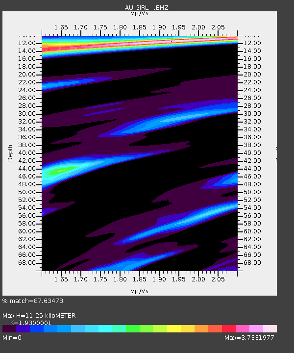
GIRL Giralia, Western Australia - Earthquake Result Viewer

Earthquake location: New Britain Region, P.N.G.
Earthquake latitude/longitude: -6.0/150.4
Earthquake time(UTC): 2010/07/18 (199) 13:04:09 GMT
Earthquake Depth: 28 km
Earthquake Magnitude: 6.3 MB, 7.1 MS, 6.9 MW, 6.8 MW
Earthquake Catalog/Contributor: WHDF/NEIC
Network: AU Australian Seismological Centre
Station: GIRL Giralia, Western Australia
Lat/Lon: 22.64 S/114.23 E
Elevation: 111 m
Distance: 38.6 deg
Az: 240.89 deg
Baz: 70.164 deg
Ray Param: 0.07539673
Estimated Moho Depth: 11.25 km
Estimated Crust Vp/Vs: 1.93
Assumed Crust Vp: 6.285 km/s
Estimated Crust Vs: 3.257 km/s
Estimated Crust Poisson's Ratio: 0.32
Radial Match: 87.63478 %
Radial Bump: 284
Transverse Match: 73.50856 %
Transverse Bump: 400
SOD ConfigId: 319893
Insert Time: 2011-01-05 06:23:34.429 +0000
GWidth: 2.5
Max Bumps: 400
Tol: 0.001

Signal To Noise

ChannelStoNSTALTA
AU:GIRL: :BHZ:20100718T13:10:59.719998Z4.81450468.037005E-61.6693316E-6
AU:GIRL: :BHN:20100718T13:10:59.719998Z1.20842425.4113802E-64.478047E-6
AU:GIRL: :BHE:20100718T13:10:59.719998Z0.66059613.5488024E-65.3721214E-6
Arrivals
Ps1.8 SECOND
PpPs4.9 SECOND
PsPs/PpSs6.7 SECOND