You are here: Home > Network List > AV - Alaska Volcano Observatory Stations List
> Station Q20K Shuyak Island, AK, USA > Earthquake Result Viewer
Q20K Shuyak Island, AK, USA - Earthquake Result Viewer
| Earthquake location: |
Philippine Islands Region |
| Earthquake latitude/longitude: |
19.3/121.2 |
| Earthquake time(UTC): |
2023/09/12 (255) 11:03:18 GMT |
| Earthquake Depth: |
41 km |
| Earthquake Magnitude: |
6.3 Mww |
| Earthquake Catalog/Contributor: |
NEIC PDE/us |
|
| Network: |
AV Alaska Volcano Observatory |
| Station: |
Q20K Shuyak Island, AK, USA |
| Lat/Lon: |
58.61 N/152.39 W |
| Elevation: |
180 m |
|
| Distance: |
71.9 deg |
| Az: |
33.337 deg |
| Baz: |
277.313 deg |
| Ray Param: |
0.053955555 |
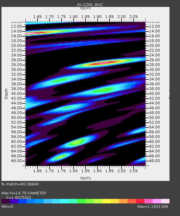
| Estimated Moho Depth: |
14.75 km |
| Estimated Crust Vp/Vs: |
1.60 |
| Assumed Crust Vp: |
5.989 km/s |
| Estimated Crust Vs: |
3.737 km/s |
| Estimated Crust Poisson's Ratio: |
0.18 |
|
| Radial Match: |
90.06648 % |
| Radial Bump: |
400 |
| Transverse Match: |
76.51036 % |
| Transverse Bump: |
400 |
| SOD ConfigId: |
31937991 |
| Insert Time: |
2023-09-26 11:14:17.607 +0000 |
| GWidth: |
2.5 |
| Max Bumps: |
400 |
| Tol: |
0.001 |
|

Signal To Noise
| Channel | StoN | STA | LTA |
| AV:Q20K: :BHZ:20230912T11:14:06.84999Z | 19.736238 | 3.609652E-6 | 1.8289462E-7 |
| AV:Q20K: :BHN:20230912T11:14:06.84999Z | 3.2795315 | 7.452083E-7 | 2.2723012E-7 |
| AV:Q20K: :BHE:20230912T11:14:06.84999Z | 6.509652 | 1.8376691E-6 | 2.8229914E-7 |
| Arrivals |
| Ps | 1.5 SECOND |
| PpPs | 6.2 SECOND |
| PsPs/PpSs | 7.7 SECOND |


