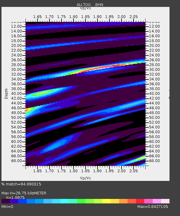
TOO Toolangi, Victoria - Earthquake Result Viewer

Earthquake location: New Britain Region, P.N.G.
Earthquake latitude/longitude: -6.0/150.4
Earthquake time(UTC): 2010/07/18 (199) 13:04:09 GMT
Earthquake Depth: 28 km
Earthquake Magnitude: 6.3 MB, 7.1 MS, 6.9 MW, 6.8 MW
Earthquake Catalog/Contributor: WHDF/NEIC
Network: AU Australian Seismological Centre
Station: TOO Toolangi, Victoria
Lat/Lon: 37.57 S/145.49 E
Elevation: 604 m
Distance: 31.8 deg
Az: 187.461 deg
Baz: 9.355 deg
Ray Param: 0.07889345
Estimated Moho Depth: 29.75 km
Estimated Crust Vp/Vs: 1.90
Assumed Crust Vp: 6.577 km/s
Estimated Crust Vs: 3.466 km/s
Estimated Crust Poisson's Ratio: 0.31
Radial Match: 94.890015 %
Radial Bump: 271
Transverse Match: 71.71677 %
Transverse Bump: 400
SOD ConfigId: 319893
Insert Time: 2011-01-05 06:23:53.759 +0000
GWidth: 2.5
Max Bumps: 400
Tol: 0.001

Signal To Noise

ChannelStoNSTALTA
AU:TOO: :BHZ:20100718T13:10:00.844998Z16.3205577.767845E-64.759547E-7
AU:TOO: :BHN:20100718T13:10:00.844998Z21.3822656.0066363E-62.8091674E-7
AU:TOO: :BHE:20100718T13:10:00.844998Z2.85536318.3402756E-72.9209158E-7
Arrivals
Ps4.4 SECOND
PpPs12 SECOND
PsPs/PpSs17 SECOND