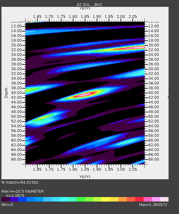
SOL AZ.SOL - Earthquake Result Viewer

Earthquake location: New Britain Region, P.N.G.
Earthquake latitude/longitude: -6.0/150.4
Earthquake time(UTC): 2010/07/18 (199) 13:04:09 GMT
Earthquake Depth: 28 km
Earthquake Magnitude: 6.3 MB, 7.1 MS, 6.9 MW, 6.8 MW
Earthquake Catalog/Contributor: WHDF/NEIC
Network: AZ ANZA Regional Network
Station: SOL AZ.SOL
Lat/Lon: 32.84 N/117.25 W
Elevation: 245 m
Distance: 95.1 deg
Az: 57.623 deg
Baz: 266.249 deg
Ray Param: 0.040848907
Estimated Moho Depth: 20.5 km
Estimated Crust Vp/Vs: 2.10
Assumed Crust Vp: 6.264 km/s
Estimated Crust Vs: 2.986 km/s
Estimated Crust Poisson's Ratio: 0.35
Radial Match: 94.01582 %
Radial Bump: 400
Transverse Match: 89.42447 %
Transverse Bump: 400
SOD ConfigId: 319893
Insert Time: 2011-01-05 06:25:27.995 +0000
GWidth: 2.5
Max Bumps: 400
Tol: 0.001

Signal To Noise

ChannelStoNSTALTA
AZ:SOL: :BHZ:20100718T13:16:58.469998Z11.32558252.2229135E-61.9627365E-7
AZ:SOL: :BHN:20100718T13:16:58.469998Z0.93914343.4245258E-73.6464357E-7
AZ:SOL: :BHE:20100718T13:16:58.469998Z1.39028664.804281E-73.4556052E-7
Arrivals
Ps3.6 SECOND
PpPs10.0 SECOND
PsPs/PpSs14 SECOND