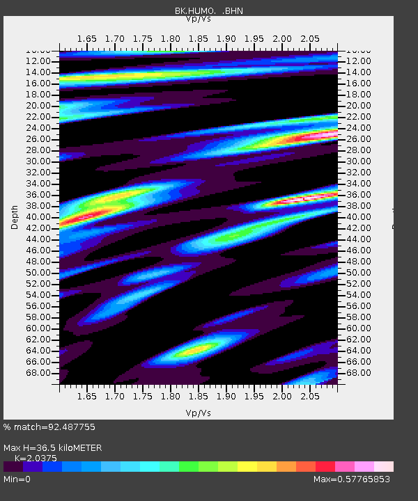
HUMO Hull Mountain, OR - Earthquake Result Viewer

Earthquake location: New Britain Region, P.N.G.
Earthquake latitude/longitude: -6.0/150.4
Earthquake time(UTC): 2010/07/18 (199) 13:04:09 GMT
Earthquake Depth: 28 km
Earthquake Magnitude: 6.3 MB, 7.1 MS, 6.9 MW, 6.8 MW
Earthquake Catalog/Contributor: WHDF/NEIC
Network: BK Berkeley Digital Seismograph Network
Station: HUMO Hull Mountain, OR
Lat/Lon: 42.61 N/122.96 W
Elevation: 555 m
Distance: 91.5 deg
Az: 47.497 deg
Baz: 263.346 deg
Ray Param: 0.0415929
Estimated Moho Depth: 36.5 km
Estimated Crust Vp/Vs: 2.04
Assumed Crust Vp: 6.522 km/s
Estimated Crust Vs: 3.201 km/s
Estimated Crust Poisson's Ratio: 0.34
Radial Match: 92.487755 %
Radial Bump: 400
Transverse Match: 81.89546 %
Transverse Bump: 400
SOD ConfigId: 319893
Insert Time: 2011-01-05 06:26:22.580 +0000
GWidth: 2.5
Max Bumps: 400
Tol: 0.001

Signal To Noise

ChannelStoNSTALTA
BK:HUMO: :BHZ:20100718T13:16:41.816982Z30.7290122.87233E-69.3472906E-8
BK:HUMO: :BHN:20100718T13:16:41.816982Z3.3638181.9592612E-75.824516E-8
BK:HUMO: :BHE:20100718T13:16:41.816982Z6.4182257.722304E-71.2031838E-7
Arrivals
Ps5.9 SECOND
PpPs17 SECOND
PsPs/PpSs23 SECOND