You are here: Home > Network List > CI - Caltech Regional Seismic Network Stations List
> Station SWS Sam W. Stewart, Westmorland, CA, USA > Earthquake Result Viewer
SWS Sam W. Stewart, Westmorland, CA, USA - Earthquake Result Viewer
| Earthquake location: |
New Britain Region, P.N.G. |
| Earthquake latitude/longitude: |
-6.0/150.4 |
| Earthquake time(UTC): |
2010/07/18 (199) 13:04:09 GMT |
| Earthquake Depth: |
28 km |
| Earthquake Magnitude: |
6.3 MB, 7.1 MS, 6.9 MW, 6.8 MW |
| Earthquake Catalog/Contributor: |
WHDF/NEIC |
|
| Network: |
CI Caltech Regional Seismic Network |
| Station: |
SWS Sam W. Stewart, Westmorland, CA, USA |
| Lat/Lon: |
32.94 N/115.80 W |
| Elevation: |
140 m |
|
| Distance: |
96.4 deg |
| Az: |
57.595 deg |
| Baz: |
267.037 deg |
| Ray Param: |
0.040523518 |
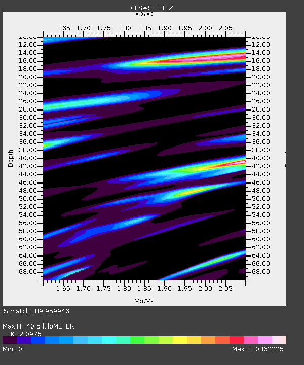
| Estimated Moho Depth: |
40.5 km |
| Estimated Crust Vp/Vs: |
2.10 |
| Assumed Crust Vp: |
6.155 km/s |
| Estimated Crust Vs: |
2.934 km/s |
| Estimated Crust Poisson's Ratio: |
0.35 |
|
| Radial Match: |
89.959946 % |
| Radial Bump: |
400 |
| Transverse Match: |
81.40312 % |
| Transverse Bump: |
400 |
| SOD ConfigId: |
319893 |
| Insert Time: |
2011-01-05 06:28:43.859 +0000 |
| GWidth: |
2.5 |
| Max Bumps: |
400 |
| Tol: |
0.001 |
|
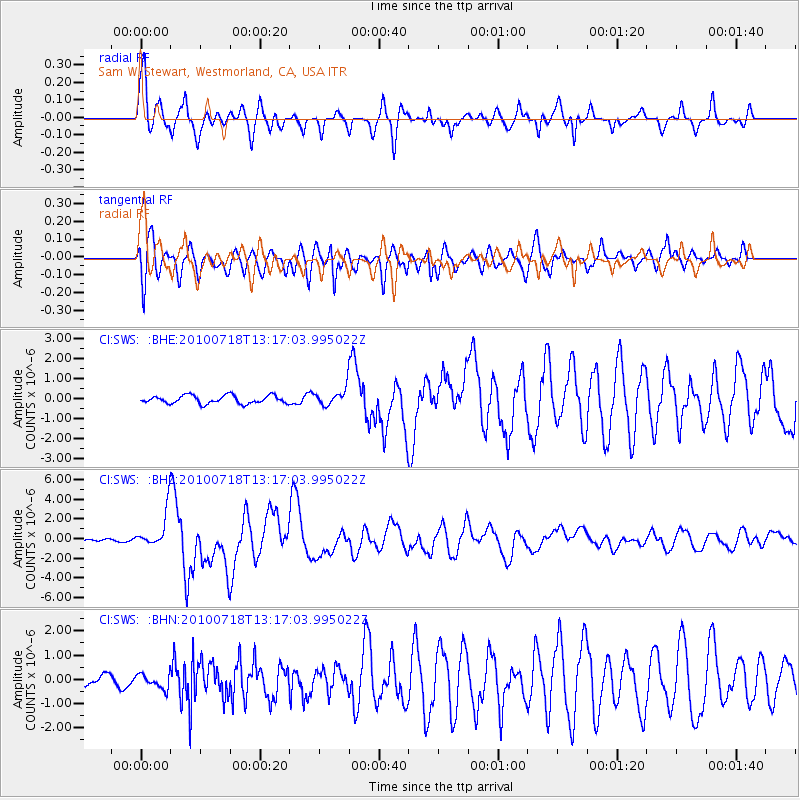
Signal To Noise
| Channel | StoN | STA | LTA |
| CI:SWS: :BHZ:20100718T13:17:03.995022Z | 12.027168 | 1.8525137E-6 | 1.5402743E-7 |
| CI:SWS: :BHN:20100718T13:17:03.995022Z | 1.1804066 | 2.9663204E-7 | 2.5129648E-7 |
| CI:SWS: :BHE:20100718T13:17:03.995022Z | 2.1861286 | 4.4579176E-7 | 2.0391836E-7 |
| Arrivals |
| Ps | 7.3 SECOND |
| PpPs | 20 SECOND |
| PsPs/PpSs | 27 SECOND |


