You are here: Home > Network List > CI - Caltech Regional Seismic Network Stations List
> Station PDM Parker Dam, Lake Havasu City, AZ, USA > Earthquake Result Viewer
PDM Parker Dam, Lake Havasu City, AZ, USA - Earthquake Result Viewer

| Earthquake location: |
New Britain Region, P.N.G. |
| Earthquake latitude/longitude: |
-6.0/150.4 |
| Earthquake time(UTC): |
2010/07/18 (199) 13:04:09 GMT |
| Earthquake Depth: |
28 km |
| Earthquake Magnitude: |
6.3 MB, 7.1 MS, 6.9 MW, 6.8 MW |
| Earthquake Catalog/Contributor: |
WHDF/NEIC |
|
| Network: |
CI Caltech Regional Seismic Network |
| Station: |
PDM Parker Dam, Lake Havasu City, AZ, USA |
| Lat/Lon: |
34.30 N/114.14 W |
| Elevation: |
144 m |
|
| Distance: |
97.8 deg |
| Az: |
56.286 deg |
| Baz: |
268.111 deg |
| Ray Param: |
0.040088873 |
| Estimated Moho Depth: |
24.75 km |
| Estimated Crust Vp/Vs: |
1.89 |
| Assumed Crust Vp: |
6.276 km/s |
| Estimated Crust Vs: |
3.321 km/s |
| Estimated Crust Poisson's Ratio: |
0.31 |
|
| Radial Match: |
95.29262 % |
| Radial Bump: |
330 |
| Transverse Match: |
75.694214 % |
| Transverse Bump: |
400 |
| SOD ConfigId: |
319893 |
| Insert Time: |
2011-01-05 06:30:27.754 +0000 |
| GWidth: |
2.5 |
| Max Bumps: |
400 |
| Tol: |
0.001 |
|
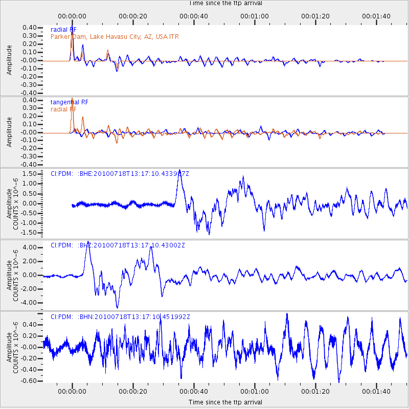
Signal To Noise
| Channel | StoN | STA | LTA |
| CI:PDM: :BHZ:20100718T13:17:10.43002Z | 14.4303255 | 1.2673217E-6 | 8.78235E-8 |
| CI:PDM: :BHN:20100718T13:17:10.451992Z | 0.87230325 | 6.562096E-8 | 7.5227234E-8 |
| CI:PDM: :BHE:20100718T13:17:10.433987Z | 4.8219886 | 3.4436798E-7 | 7.1416174E-8 |
| Arrivals |
| Ps | 3.6 SECOND |
| PpPs | 11 SECOND |
| PsPs/PpSs | 15 SECOND |


