You are here: Home > Network List > US - United States National Seismic Network Stations List
> Station HAWA Hanford, Washington, USA > Earthquake Result Viewer
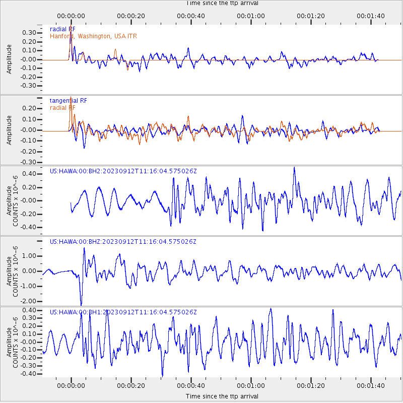
HAWA Hanford, Washington, USA - Earthquake Result Viewer
*The percent match for this event was below the threshold and hence no stack was calculated.
| Earthquake location: |
Philippine Islands Region |
| Earthquake latitude/longitude: |
19.3/121.2 |
| Earthquake time(UTC): |
2023/09/12 (255) 11:03:18 GMT |
| Earthquake Depth: |
41 km |
| Earthquake Magnitude: |
6.3 Mww |
| Earthquake Catalog/Contributor: |
NEIC PDE/us |
|
| Network: |
US United States National Seismic Network |
| Station: |
HAWA Hanford, Washington, USA |
| Lat/Lon: |
46.39 N/119.53 W |
| Elevation: |
364 m |
|
| Distance: |
94.7 deg |
| Az: |
37.299 deg |
| Baz: |
304.202 deg |
| Ray Param: |
$rayparam |
*The percent match for this event was below the threshold and hence was not used in the summary stack. |
|
| Radial Match: |
67.42329 % |
| Radial Bump: |
400 |
| Transverse Match: |
70.70585 % |
| Transverse Bump: |
400 |
| SOD ConfigId: |
31937991 |
| Insert Time: |
2023-09-26 11:29:34.226 +0000 |
| GWidth: |
2.5 |
| Max Bumps: |
400 |
| Tol: |
0.001 |
|
Signal To Noise
| Channel | StoN | STA | LTA |
| US:HAWA:00:BHZ:20230912T11:16:04.575026Z | 5.327178 | 8.430441E-7 | 1.5825341E-7 |
| US:HAWA:00:BH1:20230912T11:16:04.575026Z | 1.9056147 | 1.4345179E-7 | 7.5278486E-8 |
| US:HAWA:00:BH2:20230912T11:16:04.575026Z | 1.4989016 | 1.6937086E-7 | 1.12996645E-7 |
| Arrivals |
| Ps | |
| PpPs | |
| PsPs/PpSs | |


