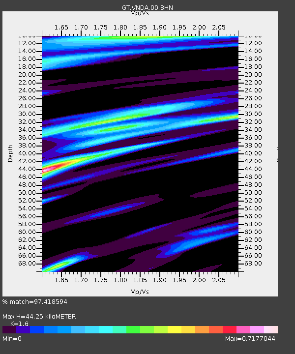
VNDA Wright Valley (Bull Pass) Antarctica - Earthquake Result Viewer
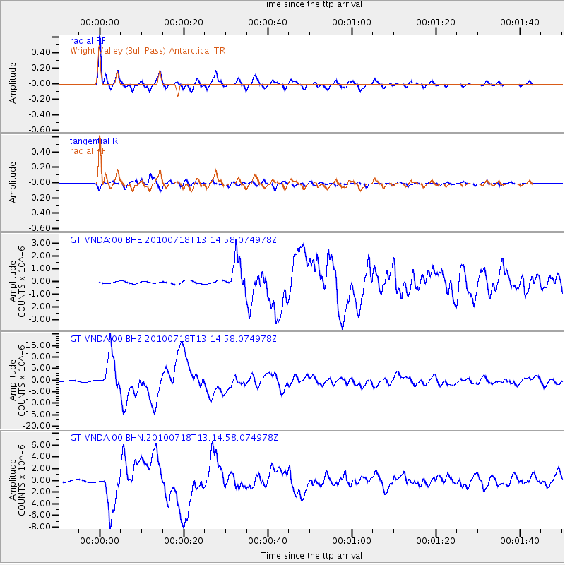
Earthquake location: New Britain Region, P.N.G.
Earthquake latitude/longitude: -6.0/150.4
Earthquake time(UTC): 2010/07/18 (199) 13:04:09 GMT
Earthquake Depth: 28 km
Earthquake Magnitude: 6.3 MB, 7.1 MS, 6.9 MW, 6.8 MW
Earthquake Catalog/Contributor: WHDF/NEIC
Network: GT Global Telemetered Seismograph Network (USAF/USGS)
Station: VNDA Wright Valley (Bull Pass) Antarctica
Lat/Lon: 77.52 S/161.85 E
Elevation: 151 m
Distance: 71.8 deg
Az: 177.4 deg
Baz: 348.028 deg
Ray Param: 0.054069396
Estimated Moho Depth: 44.25 km
Estimated Crust Vp/Vs: 1.60
Assumed Crust Vp: 6.245 km/s
Estimated Crust Vs: 3.903 km/s
Estimated Crust Poisson's Ratio: 0.18
Radial Match: 97.418594 %
Radial Bump: 400
Transverse Match: 93.17442 %
Transverse Bump: 400
SOD ConfigId: 319893
Insert Time: 2011-01-05 06:32:24.632 +0000
GWidth: 2.5
Max Bumps: 400
Tol: 0.001

Signal To Noise

ChannelStoNSTALTA
GT:VNDA:00:BHZ:20100718T13:14:58.074978Z29.626787.815331E-62.637928E-7
GT:VNDA:00:BHN:20100718T13:14:58.074978Z19.3259013.399562E-61.7590703E-7
GT:VNDA:00:BHE:20100718T13:14:58.074978Z12.8248151.2399208E-69.668138E-8
Arrivals
Ps4.4 SECOND
PpPs18 SECOND
PsPs/PpSs22 SECOND