You are here: Home > Network List > UW - Pacific Northwest Regional Seismic Network Stations List
> Station HOOD Mt Hood Meadows, OR CREST BB SMO > Earthquake Result Viewer
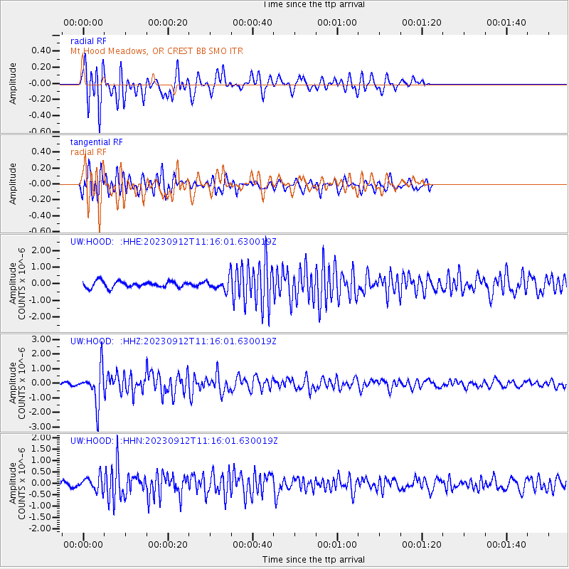
HOOD Mt Hood Meadows, OR CREST BB SMO - Earthquake Result Viewer
*The percent match for this event was below the threshold and hence no stack was calculated.
| Earthquake location: |
Philippine Islands Region |
| Earthquake latitude/longitude: |
19.3/121.2 |
| Earthquake time(UTC): |
2023/09/12 (255) 11:03:18 GMT |
| Earthquake Depth: |
41 km |
| Earthquake Magnitude: |
6.3 Mww |
| Earthquake Catalog/Contributor: |
NEIC PDE/us |
|
| Network: |
UW Pacific Northwest Regional Seismic Network |
| Station: |
HOOD Mt Hood Meadows, OR CREST BB SMO |
| Lat/Lon: |
45.32 N/121.65 W |
| Elevation: |
1520 m |
|
| Distance: |
94.1 deg |
| Az: |
39.013 deg |
| Baz: |
302.553 deg |
| Ray Param: |
$rayparam |
*The percent match for this event was below the threshold and hence was not used in the summary stack. |
|
| Radial Match: |
75.49394 % |
| Radial Bump: |
392 |
| Transverse Match: |
75.63675 % |
| Transverse Bump: |
400 |
| SOD ConfigId: |
31937991 |
| Insert Time: |
2023-09-26 11:31:01.132 +0000 |
| GWidth: |
2.5 |
| Max Bumps: |
400 |
| Tol: |
0.001 |
|
Signal To Noise
| Channel | StoN | STA | LTA |
| UW:HOOD: :HHZ:20230912T11:16:01.630019Z | 6.800338 | 1.2489899E-6 | 1.8366586E-7 |
| UW:HOOD: :HHN:20230912T11:16:01.630019Z | 2.4550538 | 3.0864936E-7 | 1.2572E-7 |
| UW:HOOD: :HHE:20230912T11:16:01.630019Z | 1.9783856 | 3.6326978E-7 | 1.836193E-7 |
| Arrivals |
| Ps | |
| PpPs | |
| PsPs/PpSs | |


